IMAGES TAKEN NEAR TO
Bunkers Hill, IVYBRIDGE, PL21 9NP
Introduction
This page details the photographs taken nearby to Bunkers Hill, PL21 9NP by members of the Geograph project.
The Geograph project started in 2005 with the aim of publishing, organising and preserving representative images for every square kilometre of Great Britain, Ireland and the Isle of Man.

There are currently over 7.5m images from over14,400 individuals and you can help contribute to the project by visiting https://www.geograph.org.uk
Image Map
Images are licensed for reuse under creativecommons.org/licenses/by-sa/2.0
Notes
- Clicking on the map will re-center to the selected point.
- The higher the marker number, the further away the image location is from the centre of the postcode.
Image Listing (55 Images Found)
Images are licensed for reuse under creativecommons.org/licenses/by-sa/2.0
Image
Details
Distance
1
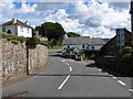
Ermington : Road
A small road off the A3121.
Image: © Lewis Clarke
Taken: 8 Jun 2021
0.02 miles
4
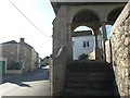
Imposing stone lychgate on Ermington main street
Image: © David Gearing
Taken: 1 Nov 2011
0.06 miles
5
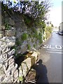
Stone drinking trough, Church Street, Ermington
More ornamental than practical in the twenty-first century
Image: © David Smith
Taken: 27 Feb 2017
0.06 miles
6
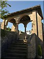
Lych gate, Ermington
The "monumental, almost Lutyenesque" (Cherry and Pevsner) lych gate dates from about 1890. Two flights of steps climb to it.
Image: © Derek Harper
Taken: 26 Jun 2009
0.07 miles
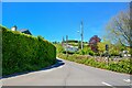
7

Looking down School Road, Ermington
This road is narrow in parts and gets very busy at times hence the need for the
traffic calming measures.
Image: © jeff collins
Taken: 26 Nov 2013
0.07 miles
8
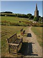
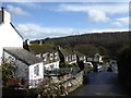
Seats by the church path
Ermington Footpath 10 leads from The Square to the church of St Peter and St Paul. It's not very far, but these seats provide somewhere to rest on the way.
Image: © Derek Harper
Taken: 26 Jun 2009
0.07 miles
9
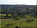
Ermington from West Strode Cross
From this angle and distance (some 800 metres) the notorious crooked spire of Ermington looks fairly straight. The village is on the northwest slope of the Erme valley. Beyond are wooded slopes on the Flete estate.
Image: © Derek Harper
Taken: 29 Aug 2006
0.08 miles