IMAGES TAKEN NEAR TO
IVYBRIDGE, PL21 9LB
Introduction
This page details the photographs taken nearby to PL21 9LB by members of the Geograph project.
The Geograph project started in 2005 with the aim of publishing, organising and preserving representative images for every square kilometre of Great Britain, Ireland and the Isle of Man.

There are currently over 7.5m images from over14,400 individuals and you can help contribute to the project by visiting https://www.geograph.org.uk
Image Map (Loading...)


Getting Data...Please wait
Leaflet Map data © OpenStreetMap
Images are licensed for reuse under creativecommons.org/licenses/by-sa/2.0
Notes
- Clicking on the map will re-center to the selected point.
- The higher the marker number, the further away the image location is from the centre of the postcode.
Image Listing (6 Images Found)
Images are licensed for reuse under creativecommons.org/licenses/by-sa/2.0
Image
Details
Distance
1
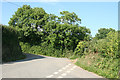
Yealmpton: Wilburton Cross
The lane running uphill goes to Winsor Cross via Knap Cross; the lane beyond the gate runs via Burraton and Luson to Westlake
Image: © Martin Bodman
Taken: 11 Jun 2010
0.06 miles
2
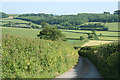
Yealmpton: by Wilburton Cross
Lane to the A379 Plymouth-Kingsbridge road. Waye Farm can be seen in the distance, left
Image: © Martin Bodman
Taken: 11 Jun 2010
0.08 miles
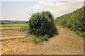
3
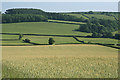
Yealmpton: wheat field
By Wilburton Cross. The A379 Plymouth-Kingsbridge road runs right across the image, indicated by the double hedge. Butland Wood stands on the skyline
Image: © Martin Bodman
Taken: 11 Jun 2010
0.10 miles
4
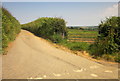
Knap Cross
The lane east of the junction, which leads to Ley Green.
Image: © Derek Harper
Taken: 23 Jun 2014
0.23 miles
5
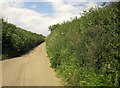
Lane at Knap Cross
On the right in the hedgebank is a mass of purple vetch.
Image: © Derek Harper
Taken: 23 Jun 2014
0.24 miles
6
Green lane to Worston
A route with public access, seen from Knap Cross.
Image: © Derek Harper
Taken: 23 Jun 2014
0.24 miles