IMAGES TAKEN NEAR TO
Evergreen Walk, PL21 9GQ
Introduction
This page details the photographs taken nearby to Evergreen Walk, PL21 9GQ by members of the Geograph project.
The Geograph project started in 2005 with the aim of publishing, organising and preserving representative images for every square kilometre of Great Britain, Ireland and the Isle of Man.

There are currently over 7.5m images from over14,400 individuals and you can help contribute to the project by visiting https://www.geograph.org.uk
Image Map
Images are licensed for reuse under creativecommons.org/licenses/by-sa/2.0
Notes
- Clicking on the map will re-center to the selected point.
- The higher the marker number, the further away the image location is from the centre of the postcode.
Image Listing (18 Images Found)
Images are licensed for reuse under creativecommons.org/licenses/by-sa/2.0
Image
Details
Distance
1
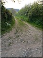
Rear track to Stibb Farm
I imagine this track is used to allow easier access to the farms fields and live stock, directly from the farm.
Image: © jeff collins
Taken: 26 Apr 2020
0.03 miles
2
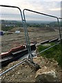
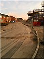
Housing development ground work
Just off Stibb Lane. This is the upper section of the new housing in; https://www.geograph.org.uk/gridref/SX6256 .
Image: © jeff collins
Taken: 26 Apr 2020
0.08 miles
3
Stibb Lane
Further along Image] . Heading towards Stibb Lane End, which is not far from Cadleigh Lodge.
Image: © jeff collins
Taken: 19 Apr 2020
0.12 miles
4
New housing estate
Image: © jeff collins
Taken: 5 Apr 2020
0.18 miles
5
New housing estate
A little further on than Image] this estate is squeezed in between Cornwood Road and Stibbs Lane.
Image: © jeff collins
Taken: 5 Apr 2020
0.18 miles
6
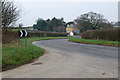
Cadleigh Lodge
Taken from the start of Lane,looking back towards Ivybridge.Cadleigh Lodge is in the background.
Image: © jeff collins
Taken: 1 Mar 2009
0.19 miles
8
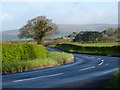
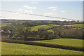
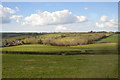
Road scene at a bend, between Lee Mill and Cornwood
Farmland predominates in this area, and the open moorland of Dartmoor can be seen in the background.
Image: © Ruth Sharville
Taken: 22 Apr 2012
0.19 miles
9
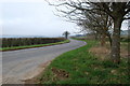
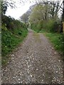
Minor road
This was taken from the start of Stibb Lane,which runs down to the A38 Dual Carriageway.A few miles further on is the village of Cornwood,just in the Dartmoor National Park.
Image: © jeff collins
Taken: 1 Mar 2009
0.20 miles