IMAGES TAKEN NEAR TO
Abbots Close, IVYBRIDGE, PL21 9GA
Introduction
This page details the photographs taken nearby to Abbots Close, PL21 9GA by members of the Geograph project.
The Geograph project started in 2005 with the aim of publishing, organising and preserving representative images for every square kilometre of Great Britain, Ireland and the Isle of Man.

There are currently over 7.5m images from over14,400 individuals and you can help contribute to the project by visiting https://www.geograph.org.uk
Image Map
Images are licensed for reuse under creativecommons.org/licenses/by-sa/2.0
Notes
- Clicking on the map will re-center to the selected point.
- The higher the marker number, the further away the image location is from the centre of the postcode.
Image Listing (22 Images Found)
Images are licensed for reuse under creativecommons.org/licenses/by-sa/2.0
Image
Details
Distance
1
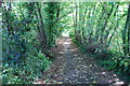
Footpath
This footpath leads from the Industrial Estate to the cycle path by the A38.
Image: © jeff collins
Taken: 14 Sep 2013
0.05 miles
2
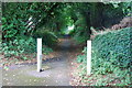
Footpath
Leading to the Lee Mill Industrial Estate from the cycle path.
Image: © jeff collins
Taken: 14 Sep 2013
0.05 miles
3
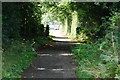
Cycle Path
Just past the Hunting Lodge.
Image: © jeff collins
Taken: 14 Sep 2013
0.06 miles
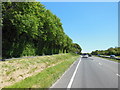
5
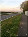
A38 Dual Carriageway
Looking West towards Plymouth. On the right is the cycle path heading towards Lee Mill.
Image: © jeff collins
Taken: 12 Apr 2020
0.07 miles
7
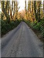
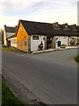
Cadleigh Lane
Looking back towards the Hunting Lodge Public House at Cadleigh Park.
Image: © jeff collins
Taken: 5 Apr 2020
0.11 miles
8
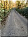
Cadleigh Lane
Looking North towards the junction with Woodland Road.
Image: © jeff collins
Taken: 5 Apr 2020
0.11 miles
9
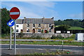
Hunting Lodge public house, Cadleigh Park
Next to the A38 dual carriageway. Now closed due to the coronavirus pandemic.
Image: © jeff collins
Taken: 5 Apr 2020
0.12 miles
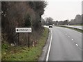
10
The Hunting Lodge Public House
Looking across the A38 from the bottom of Hunsdon Road where it merges with the A38 West bound.
Image: © jeff collins
Taken: 4 Sep 2013
0.13 miles