IMAGES TAKEN NEAR TO
Central Avenue, IVYBRIDGE, PL21 9ER
Introduction
This page details the photographs taken nearby to Central Avenue, PL21 9ER by members of the Geograph project.
The Geograph project started in 2005 with the aim of publishing, organising and preserving representative images for every square kilometre of Great Britain, Ireland and the Isle of Man.

There are currently over 7.5m images from over14,400 individuals and you can help contribute to the project by visiting https://www.geograph.org.uk
Image Map
Images are licensed for reuse under creativecommons.org/licenses/by-sa/2.0
Notes
- Clicking on the map will re-center to the selected point.
- The higher the marker number, the further away the image location is from the centre of the postcode.
Image Listing (15 Images Found)
Images are licensed for reuse under creativecommons.org/licenses/by-sa/2.0
Image
Details
Distance
1
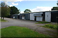
Empty Units
On the Lee Mill Industrial Estate.
Image: © jeff collins
Taken: 14 Sep 2013
0.04 miles
2
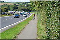
Cycle Path
Along side the A38 close to Tesco.
Image: © jeff collins
Taken: 14 Sep 2013
0.06 miles
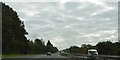
3
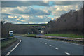
Ermington : Devon Expressway A38
Looking along the Devon Expressway A38.
Image: © Lewis Clarke
Taken: 3 Dec 2019
0.07 miles
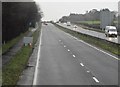
5
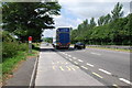
A38 Dual Carriageway
Looking West bound,just past the Hunting Lodge Inn.
Image: © jeff collins
Taken: 27 Jun 2009
0.16 miles
6
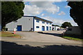
Warehousing on the Lee Mill Industrial Estate
Image: © jeff collins
Taken: 14 Sep 2013
0.16 miles
8
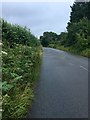
Minor road
Beech Road, heading in the direction of Cornwood.
Image: © jeff collins
Taken: 16 Aug 2020
0.20 miles
9
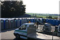
Portable toilets in Elliott Loohire depot
Image: © chris almond
Taken: 15 Feb 2006
0.20 miles
10
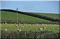
South Hams : Sheep Grazing
Sheep grazing in a field beside the A38 road.
Image: © Lewis Clarke
Taken: 22 May 2013
0.21 miles