IMAGES TAKEN NEAR TO
Manor Drive, IVYBRIDGE, PL21 9BE
Introduction
This page details the photographs taken nearby to Manor Drive, PL21 9BE by members of the Geograph project.
The Geograph project started in 2005 with the aim of publishing, organising and preserving representative images for every square kilometre of Great Britain, Ireland and the Isle of Man.

There are currently over 7.5m images from over14,400 individuals and you can help contribute to the project by visiting https://www.geograph.org.uk
Image Map
Images are licensed for reuse under creativecommons.org/licenses/by-sa/2.0
Notes
- Clicking on the map will re-center to the selected point.
- The higher the marker number, the further away the image location is from the centre of the postcode.
Image Listing (32 Images Found)
Images are licensed for reuse under creativecommons.org/licenses/by-sa/2.0
Image
Details
Distance
2
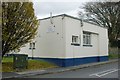
Ivybridge Old Fire Station
Ivybridge old fire station, Western Road, Ivybridge, Devon. Now used as a children's nursery.
Image: © Kevin Hale
Taken: 7 Dec 2005
0.15 miles
4
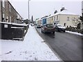
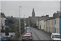
Western Road, Ivybridge
Snowy scene . Looking East towards the town centre
Image: © jeff collins
Taken: 28 Feb 2018
0.16 miles
6
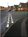
Road Junction
Junction of Julian Rd on the right with Cleeve Drive.
Image: © jeff collins
Taken: 10 Apr 2020
0.16 miles
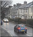
9
Western Rd
Looking away from Ivybridge town centre.
Image: © jeff collins
Taken: 11 Apr 2020
0.16 miles