IMAGES TAKEN NEAR TO
Modbury, IVYBRIDGE, PL21 0TW
Introduction
This page details the photographs taken nearby to PL21 0TW by members of the Geograph project.
The Geograph project started in 2005 with the aim of publishing, organising and preserving representative images for every square kilometre of Great Britain, Ireland and the Isle of Man.

There are currently over 7.5m images from over14,400 individuals and you can help contribute to the project by visiting https://www.geograph.org.uk
Image Map
Images are licensed for reuse under creativecommons.org/licenses/by-sa/2.0
Notes
- Clicking on the map will re-center to the selected point.
- The higher the marker number, the further away the image location is from the centre of the postcode.
Image Listing (5 Images Found)
Images are licensed for reuse under creativecommons.org/licenses/by-sa/2.0
Image
Details
Distance
1
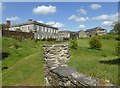
Shilstone House and outbuildings
Taken from the track leading down to the ponds. Shilstone House has been the subject of a major restoration that began in 2002 and is still not quite complete. The house and grounds are used as a wedding venue. The Devon Rural Archive building is also on the site.
Image: © David Gearing
Taken: 2 May 2017
0.07 miles
2
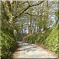
Ridge Road in woodland with footpath sign
The footpath leads diagonally across a field to a bridleway at Shilston Barton
Image: © David Smith
Taken: 16 Apr 2015
0.20 miles
3
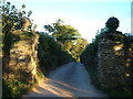
Shilston Gate
Modbury Bridleway 11 leads past these gateposts down past Shilston Barton. Taken from Ridge Road.
Image: © Derek Harper
Taken: 29 Aug 2006
0.21 miles
4
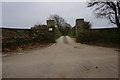
Shilston Gate
Gone are the granite gate pillars as seen in other photos in this square, replaced with these look alike ones. This is the entrance to Shilston Barton a venue for weddings and other such events.
Image: © jeff collins
Taken: 11 Mar 2014
0.21 miles
5
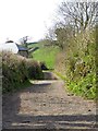
Track to Ludbrook from Shilston Gate
At the house, the track turns left and follows a contour around the hill
Image: © David Smith
Taken: 16 Apr 2015
0.24 miles