IMAGES TAKEN NEAR TO
Modbury, IVYBRIDGE, PL21 0TQ
Introduction
This page details the photographs taken nearby to PL21 0TQ by members of the Geograph project.
The Geograph project started in 2005 with the aim of publishing, organising and preserving representative images for every square kilometre of Great Britain, Ireland and the Isle of Man.

There are currently over 7.5m images from over14,400 individuals and you can help contribute to the project by visiting https://www.geograph.org.uk
Image Map
Images are licensed for reuse under creativecommons.org/licenses/by-sa/2.0
Notes
- Clicking on the map will re-center to the selected point.
- The higher the marker number, the further away the image location is from the centre of the postcode.
Image Listing (9 Images Found)
Images are licensed for reuse under creativecommons.org/licenses/by-sa/2.0
Image
Details
Distance
1
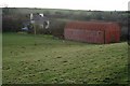
Shearlangstone
A big red corrugated iron barn dominates the view from the valley side.
Image: © Tony Atkin
Taken: 24 Jan 2010
0.08 miles
2
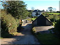
Shearlangstone
Farmhouse and outbuildings in South Hams, seen from the lane between Kingston and Modbury.
Image: © Derek Harper
Taken: 4 Nov 2006
0.09 miles
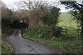
3
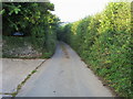
Narrow country lane
Narrow country lane passing Higher Shearlangston
Image: © Shaun Ferguson
Taken: 15 Aug 2010
0.19 miles
4
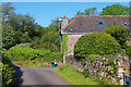
Wastor Park
Looking down the road towards Wastor Park.
Image: © Wayland Smith
Taken: 20 May 2023
0.20 miles
5

Track near Wastor
A track leads up from the valley below Wastor.
Image: © Derek Harper
Taken: 4 Nov 2006
0.21 miles
6
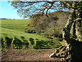
Field below Wastor Park
Looking past an oak tree with the track in Image on the right (reverse view), and Wastor Wood ahead.
Image: © Derek Harper
Taken: 4 Nov 2006
0.21 miles
7
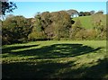
Shadows in valley below Wastor
The stream runs to the left through the trees on its way to the Erme estuary just over a mile away. Beyond, a field rises steeply beside Wastor Wood.
Image: © Derek Harper
Taken: 4 Nov 2006
0.21 miles
9
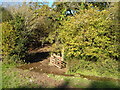
Stream through gateway near Wastor
The conservation walk site http://cwr.defra.gov.uk/Default.aspx?Module=CountryWalkDetails&Site=2617 mentions that "the southern section is through pleasant woodland with an attractive stream flowing through it". Here the stream occupies the entire gateway through which the walk passes, requiring agile footwork, though someone has provided a few inadequate stepping stones.
Image: © Derek Harper
Taken: 4 Nov 2006
0.24 miles