IMAGES TAKEN NEAR TO
Modbury, IVYBRIDGE, PL21 0SB
Introduction
This page details the photographs taken nearby to PL21 0SB by members of the Geograph project.
The Geograph project started in 2005 with the aim of publishing, organising and preserving representative images for every square kilometre of Great Britain, Ireland and the Isle of Man.

There are currently over 7.5m images from over14,400 individuals and you can help contribute to the project by visiting https://www.geograph.org.uk
Image Map
Images are licensed for reuse under creativecommons.org/licenses/by-sa/2.0
Notes
- Clicking on the map will re-center to the selected point.
- The higher the marker number, the further away the image location is from the centre of the postcode.
Image Listing (7 Images Found)
Images are licensed for reuse under creativecommons.org/licenses/by-sa/2.0
Image
Details
Distance
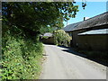
1
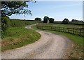
Farm road to Heathfield Down
A curving track leaves the lane between Heathfield Cross and Lixton.
Image: © Derek Harper
Taken: 26 Jun 2009
0.05 miles
2
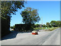
Entrance to Pennymoor caravan and campsite
A quiet and secluded site close to Modbury.
Image: © Anthony Vosper
Taken: 15 Jul 2021
0.17 miles
3
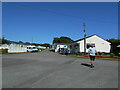
Pennymoor campsite
Mobile homes and the reception and cafe to this well equipped caravan and camp site.
Image: © Anthony Vosper
Taken: 15 Jul 2021
0.19 miles
4
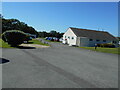
Pennymoor campsite
The washing and toilet block to a well equipped caravan and campsite.
Image: © Anthony Vosper
Taken: 15 Jul 2021
0.20 miles
5
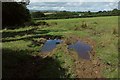
Field near Pennymoor
A damp field entrance east of Pennymoor Caravan and Camping Park, looking towards East Leigh, with Dartmoor on the horizon.
Image: © Derek Harper
Taken: 27 Aug 2015
0.22 miles
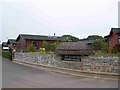
6
The road past Heathfield Manor farm
Quite a large farm complex running parallel to the road.
Image: © Anthony Vosper
Taken: 15 Jul 2021
0.23 miles
7
The Thatches Holiday Village
The Thatches is a couple of miles outside Modbury and adjacent to the Pennymoor Caravan site where we were stopping.
Image: © Michael Knapton
Taken: 29 Jun 2006
0.25 miles