IMAGES TAKEN NEAR TO
Modbury, IVYBRIDGE, PL21 0SA
Introduction
This page details the photographs taken nearby to PL21 0SA by members of the Geograph project.
The Geograph project started in 2005 with the aim of publishing, organising and preserving representative images for every square kilometre of Great Britain, Ireland and the Isle of Man.

There are currently over 7.5m images from over14,400 individuals and you can help contribute to the project by visiting https://www.geograph.org.uk
Image Map
Images are licensed for reuse under creativecommons.org/licenses/by-sa/2.0
Notes
- Clicking on the map will re-center to the selected point.
- The higher the marker number, the further away the image location is from the centre of the postcode.
Image Listing (11 Images Found)
Images are licensed for reuse under creativecommons.org/licenses/by-sa/2.0
Image
Details
Distance
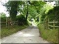
1
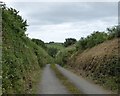
Lane, Widland
An ultra-dappled lane winds seductively away from the Ayleston Brook towards Babland Farm.
Image: © Derek Harper
Taken: 26 Jun 2009
0.11 miles
2
Field at Ayleston Cross
Silage bales at the side of a field above the Ayleston Brook valley in the background.
Image: © Derek Harper
Taken: 26 Jun 2009
0.11 miles
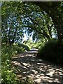
3
Country road - Devon
Devon has a lot of roads. Most of them are rather quiet - except maybe in high summer. Here's an example from the South Hams.
Image: © Richard Knights
Taken: 20 May 2001
0.12 miles
4
Looking south from Ayleston Cross
A minor road into the valley south of the crossroads
Image: © David Smith
Taken: 1 Jul 2016
0.14 miles
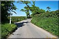
5
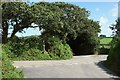
Ayleston Cross
A slightly offset crossroads east of Modbury. The footpath sign indicates steps up to a stile taking Modbury Footpath 3 to West Leigh.
Image: © Derek Harper
Taken: 27 Aug 2015
0.14 miles
6
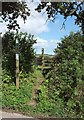
Stile, Ayleston Cross
Steps climb to a stile giving access to Modbury Footpath 3; this is also visible in Image
Image: © Derek Harper
Taken: 27 Aug 2015
0.14 miles
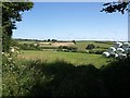
7
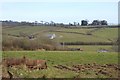
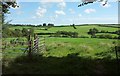
Across the Valley from Ayleston Cross
Looking southeast across the valley.
Image: © Tony Atkin
Taken: 13 Mar 2010
0.15 miles
8
View from Ayleston Cross
Very similar scenes are at Image and Image The roofs visible left of centre in the valley belong to Widland Farm.
Image: © Derek Harper
Taken: 27 Aug 2015
0.17 miles
9
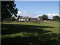
Ayleston
The farm seen from Modbury Footpath 3 as it leaves Ayleston Cross.
Image: © Derek Harper
Taken: 26 Jun 2009
0.20 miles