IMAGES TAKEN NEAR TO
Modbury, IVYBRIDGE, PL21 0LW
Introduction
This page details the photographs taken nearby to PL21 0LW by members of the Geograph project.
The Geograph project started in 2005 with the aim of publishing, organising and preserving representative images for every square kilometre of Great Britain, Ireland and the Isle of Man.

There are currently over 7.5m images from over14,400 individuals and you can help contribute to the project by visiting https://www.geograph.org.uk
Image Map (Loading...)


Getting Data...Please wait
Leaflet Map data © OpenStreetMap
Images are licensed for reuse under creativecommons.org/licenses/by-sa/2.0
Notes
- Clicking on the map will re-center to the selected point.
- The higher the marker number, the further away the image location is from the centre of the postcode.
Image Listing (6 Images Found)
Images are licensed for reuse under creativecommons.org/licenses/by-sa/2.0
Image
Details
Distance
1
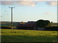
Barn near Modbury
An old barn still just about in working order on a field boundary northeast of Modbury. Seen from the lane between mary Cross and Sheepham.
Image: © Derek Harper
Taken: 29 Aug 2006
0.14 miles
2
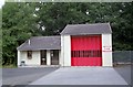
Modbury Fire Station
Modbury Fire Station, Dark Lane, Modbury, Devon. This station replaces the old fire station Image
Image: © Kevin Hale
Taken: 13 Jul 1995
0.14 miles
3
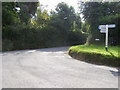
Little Sheepham Cross
Little Sheepham Cross at the junction of Dark Lane and Barracks Road
Image: © Shaun Ferguson
Taken: 11 Aug 2010
0.20 miles
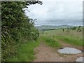
4
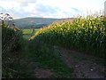
Maize field and view
The west side of the maize field in Image, seen from the road between Mary Cross and Sheepham. The hedge on the far side of the Sheepham Brook valley leads up to Ridge Road, approximately from where Image was taken. (This point is at the extreme top left of that photo). In the distance, Western Beacon and southern Dartmoor.
Image: © Derek Harper
Taken: 29 Aug 2006
0.20 miles
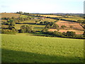
5
The valley of the Sheepham Brook
Looking north across the valley from near Mary Cross. The bird is a buzzard
Image: © David Smith
Taken: 1 Jul 2016
0.23 miles
6
Little Sheepham
Looking from Ridge Road across the Sheepham Brook valley in the South Hams. About 4 squares in this shot. The lane past the farm links Mary Cross to Sheepham Bridge.
Image: © Derek Harper
Taken: 29 Aug 2006
0.24 miles