IMAGES TAKEN NEAR TO
Ugborough, IVYBRIDGE, PL21 0HW
Introduction
This page details the photographs taken nearby to PL21 0HW by members of the Geograph project.
The Geograph project started in 2005 with the aim of publishing, organising and preserving representative images for every square kilometre of Great Britain, Ireland and the Isle of Man.

There are currently over 7.5m images from over14,400 individuals and you can help contribute to the project by visiting https://www.geograph.org.uk
Image Map (Loading...)


Getting Data...Please wait
Leaflet Map data © OpenStreetMap
Images are licensed for reuse under creativecommons.org/licenses/by-sa/2.0
Notes
- Clicking on the map will re-center to the selected point.
- The higher the marker number, the further away the image location is from the centre of the postcode.
Image Listing (12 Images Found)
Images are licensed for reuse under creativecommons.org/licenses/by-sa/2.0
Image
Details
Distance
1
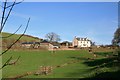
Fowlescombe Farm and Visitors Centre
Fowlescombe Farm (previously know as Bolterscombe) was the home farm to the Fowlescombe Estate and mansion. The current residence was created from 2000 to 2002 from the original Georgian farm house, a much older cottage to the rear and a shippon barn originally built in the early 19th century. The Visitors Centre and two cottages, to the left, were created from a traditional Devon barn complex in 2004
Image: © Richard Barker
Taken: 4 Feb 2008
0.01 miles
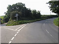
2
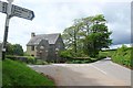
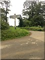
Fowlescombe Gate
Fowlescombe Lodge is shown more clearly in Image The listed gate piers are described at https://www.historicengland.org.uk/listing/the-list/list-entry/1107340 ; a repair has been carried out in the intervening 30 years since it was written. The signpost can be seen in Image The main road here is the B3196.
Image: © Derek Harper
Taken: 18 May 2017
0.18 miles
3
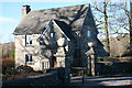
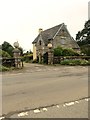
Fowlescombe Lodge
Fowlescombe Lodge, renovated in 1999 having been a ruin, is the east entrance to the Fowlescombe Estate. The gate posts are listed. The old mansion is a listed ruin. The original home farm, Bolterscombe, has now been renovated and forms Fowlescombe Farm
Image: © Richard Barker
Taken: 21 Jan 2011
0.19 miles
4
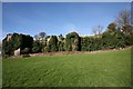
Fowlescombe Manor House or Mansion
Fowlescombe Manor House or Mansion became ruinous between 1860 and 1880. It is now a 'listed ruin with ivy'
Thomas Fowell built a medieval hall house in the centre of the valley in 1537, possibly on the site of an earlier house. For over two centuries this estate, known as Fowelscombe or Vowelscombe, remained in the hands of the Fowell family. It was later owned by the King family
Image: © Richard Barker
Taken: 4 Feb 2008
0.19 miles
6
Fowelscombe Lodge
At one of the entrances to Fowelscombe Estate. Seen across the B3196, Kingsbridge Road.
Image: © jeff collins
Taken: 1 Jul 2020
0.22 miles
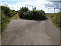
7
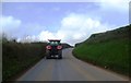
Lane to Oakpark Cross
Then the lane joins the A3121, just outside Ugborough.
Image: © jeff collins
Taken: 23 Jul 2020
0.23 miles
8
Fowelscombe Gate
On the Kingsbridge Road.
Image: © jeff collins
Taken: 1 Jul 2020
0.24 miles
9
Fowelscombe Gate
B3196 at Fowelscombe Gate
Image: © Shaun Ferguson
Taken: 15 Aug 2010
0.24 miles
10
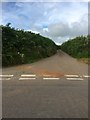
Roperidge Cross
Spriddlescombe Lane on the left continues along a ridge in the South Hams, while the driveable lane from Longford Down Head starts to drop towards Ugborough.
Image: © Derek Harper
Taken: 29 Aug 2006
0.24 miles