IMAGES TAKEN NEAR TO
Gorse Way, IVYBRIDGE, PL21 0GA
Introduction
This page details the photographs taken nearby to Gorse Way, PL21 0GA by members of the Geograph project.
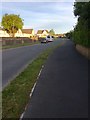
The Geograph project started in 2005 with the aim of publishing, organising and preserving representative images for every square kilometre of Great Britain, Ireland and the Isle of Man.

There are currently over 7.5m images from over14,400 individuals and you can help contribute to the project by visiting https://www.geograph.org.uk
Image Map (Loading...)


Getting Data...Please wait
Leaflet Map data © OpenStreetMap
Images are licensed for reuse under creativecommons.org/licenses/by-sa/2.0
Notes
- Clicking on the map will re-center to the selected point.
- The higher the marker number, the further away the image location is from the centre of the postcode.
Image Listing (16 Images Found)
Images are licensed for reuse under creativecommons.org/licenses/by-sa/2.0
Image
Details
Distance
1
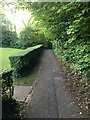
Footpath
Starting on the Exeter Rd, winding down between the housing estates to link up with Godwell Lane.
Image: © jeff collins
Taken: 9 May 2020
0.06 miles
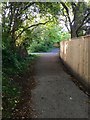
2
Footpath
Going from Exeter Rd to Godwell Lane.
Image: © jeff collins
Taken: 9 May 2020
0.11 miles
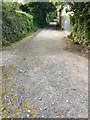
3
Filham Moor Lane
This Bridleway heads towards the lower end of Godwell Lane.
Image: © jeff collins
Taken: 2 May 2020
0.13 miles
4
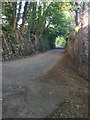
Godwell Lane
Looking in a Southwesterly direction.
Image: © jeff collins
Taken: 9 May 2020
0.14 miles
5
Woolcombe Lane
Looking in the direction of the town centre.
Image: © jeff collins
Taken: 2 May 2020
0.16 miles
6
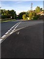
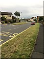
Road Junction
The junction of Woolcombe Lane on the right with St Peters Way. In the distance the bridge carrying the A38 over St Peters Way is just visible.
Image: © jeff collins
Taken: 2 May 2020
0.16 miles
7
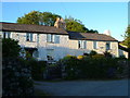
Torrhill Cottages, Godwell Lane
Godwell Lane remains a winding narrow thoroughfare, and these cottages look very rural, but they are now sandwiched between the A38 expressway and the housing estates on the southeast side of Ivybridge.
Image: © Derek Harper
Taken: 4 Jun 2006
0.20 miles
8
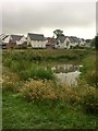
New housing at Ivybridge
Looking towards the Lucerne Fields housing development on the outskirts of Ivybridge.
Image: © jeff collins
Taken: 20 Jun 2020
0.21 miles
10
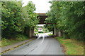
Road Bridge
This bridge carries the A38 Dual Carriage over the minor road which leads to Ermington.
Image: © jeff collins
Taken: 18 Sep 2013
0.23 miles