IMAGES TAKEN NEAR TO
Bere Ferrers, YELVERTON, PL20 7LB
Introduction
This page details the photographs taken nearby to PL20 7LB by members of the Geograph project.
The Geograph project started in 2005 with the aim of publishing, organising and preserving representative images for every square kilometre of Great Britain, Ireland and the Isle of Man.

There are currently over 7.5m images from over14,400 individuals and you can help contribute to the project by visiting https://www.geograph.org.uk
Image Map (Loading...)


Getting Data...Please wait
Leaflet Map data © OpenStreetMap
Images are licensed for reuse under creativecommons.org/licenses/by-sa/2.0
Notes
- Clicking on the map will re-center to the selected point.
- The higher the marker number, the further away the image location is from the centre of the postcode.
Image Listing (35 Images Found)
Images are licensed for reuse under creativecommons.org/licenses/by-sa/2.0
Image
Details
Distance
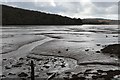
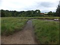
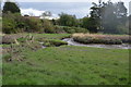
3
Tidal Ford at Bere Ferrers
This tidal ford is found further down the estuary from Bere Ferrers.
Image: © John Walton
Taken: 22 Sep 2013
0.03 miles
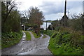
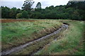
6
Ford from Hallodene to Gnatham
A convenient way for farm vehicles to cross the stream
Image: © David Smith
Taken: 13 Aug 2013
0.05 miles
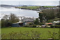
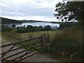
7
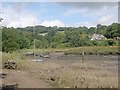
Gnatham
An inlet and mooring on the Tavy Estuary.
Image: © Tony Atkin
Taken: 19 Aug 2005
0.06 miles
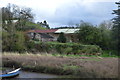
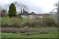
9
Gnatham Farm
Beyond the farm is the tidal section of the river Tavy
Image: © David Smith
Taken: 13 Aug 2013
0.07 miles