IMAGES TAKEN NEAR TO
Shutecombe Terrace, YELVERTON, PL20 7JZ
Introduction
This page details the photographs taken nearby to Shutecombe Terrace, PL20 7JZ by members of the Geograph project.
The Geograph project started in 2005 with the aim of publishing, organising and preserving representative images for every square kilometre of Great Britain, Ireland and the Isle of Man.

There are currently over 7.5m images from over14,400 individuals and you can help contribute to the project by visiting https://www.geograph.org.uk
Image Map (Loading...)


Getting Data...Please wait
Leaflet Map data © OpenStreetMap
Images are licensed for reuse under creativecommons.org/licenses/by-sa/2.0
Notes
- Clicking on the map will re-center to the selected point.
- The higher the marker number, the further away the image location is from the centre of the postcode.
Image Listing (110 Images Found)
Images are licensed for reuse under creativecommons.org/licenses/by-sa/2.0
Image
Details
Distance
2
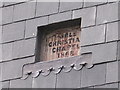
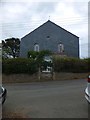
Bere Ferrers, old Bible Christian Chapel, gable-end detail
Detail on the gable-end reads "Bible Christian Chapel 1868".
For wider view of building see http://www.geograph.org.uk/photo/1948342
Image: © dave riley
Taken: 23 Jun 2009
0.02 miles
3
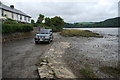
Tidal Ford at Bere Ferrers
This tidal ford is found on the edge of the village of Bere Ferrers.
Image: © John Walton
Taken: 22 Sep 2013
0.03 miles
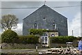
5
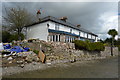
Former Bible Christian Chapel in Bere Ferrers
Now a private house; the stone dates the building as 1868
Image: © David Smith
Taken: 13 Aug 2013
0.03 miles
6
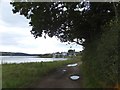
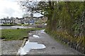
Tamar Valley Discovery Trail approaching Bere Ferrers
The trail joins the road close to the quay at Bere Ferrers.
Image: © David Smith
Taken: 13 Aug 2013
0.03 miles
8
Bere Ferrers the tide is out
A much better picture with the tide in the River Tavy here is very wide and the tide goes out a long way.
Image: © roger geach
Taken: 6 Jul 2010
0.03 miles
9
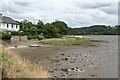
Bere Ferrers: upstream towards Maristow
Maristow House lies hidden among woods, well beyond the square, above the white vessel. The Tavy estuary with the tide out
Image: © Martin Bodman
Taken: 11 Jul 2010
0.03 miles
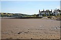
10
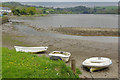
River Tavy, Bere Ferrers
The tidal River Tavy forms the eastern side of the Bere peninsula, a spit of land south-west of Tavistock. Bere Alston is the principal settlement with Bere Ferrers a smaller village towards the south end. This view is looking up the river from the old quay.
Image: © Stephen McKay
Taken: 28 Apr 2018
0.05 miles