IMAGES TAKEN NEAR TO
Woolacombe Road, YELVERTON, PL20 7EA
Introduction
This page details the photographs taken nearby to Woolacombe Road, PL20 7EA by members of the Geograph project.
The Geograph project started in 2005 with the aim of publishing, organising and preserving representative images for every square kilometre of Great Britain, Ireland and the Isle of Man.

There are currently over 7.5m images from over14,400 individuals and you can help contribute to the project by visiting https://www.geograph.org.uk
Image Map (Loading...)


Getting Data...Please wait
Leaflet Map data © OpenStreetMap
Images are licensed for reuse under creativecommons.org/licenses/by-sa/2.0
Notes
- Clicking on the map will re-center to the selected point.
- The higher the marker number, the further away the image location is from the centre of the postcode.
Image Listing (11 Images Found)
Images are licensed for reuse under creativecommons.org/licenses/by-sa/2.0
Image
Details
Distance
1
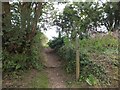
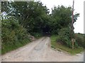
Footpath to High Cross
The path to High Cross Image] is part of the Tamar Valley Discovery Trail, signed with an apple on the upright
Image: © David Smith
Taken: 13 Aug 2013
0.11 miles
2
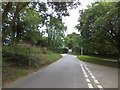
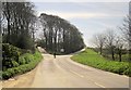
Woolacombe Cross
Four roads, two tracks and a footpath meet here, at the head of a long (for this peninsula) valley leading to the River Tavy. On the left is a sign for the footpath which forms a short part of the Tamar Valley Discovery Trail.
Image: © David Smith
Taken: 13 Aug 2013
0.11 miles
3
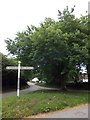
Woolacombe Cross
Four roads, two tracks and a footpath meet here, at the head of a long (for this peninsula) valley leading to the River Tavy. On the triangle of grass is a well-established field maple tree
Image: © David Smith
Taken: 13 Aug 2013
0.11 miles
4
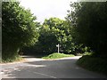
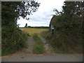
Woolacombe Cross
A meeting of five roads, a bridleway and a footpath.
Image: © Tony Atkin
Taken: 19 Aug 2005
0.12 miles
5
Private track from Woolacombe Cross
The track leads across farmland to Fishacre Wood
Image: © David Smith
Taken: 13 Aug 2013
0.16 miles
6
Entrance to field opposite Woolacombe Farm
The gatepost on the left is granite, on the right is one of wood, and there is a small barn in the field
Image: © David Smith
Taken: 13 Aug 2013
0.21 miles
7
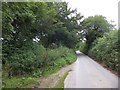
A sunken lane near Woolacombe Cross
On the left of the modern road, there is a sunken lane, now hidden by nettles. Like many parts of Devon, the Bere Ferrers peninsula is criss-crossed by medieval tracks. This one was evidently not worth saving for modern use.
Image: © David Smith
Taken: 13 Aug 2013
0.21 miles
8
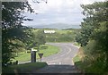
Tavistock Cross
In the distance, the hills of north Dartmoor. This crossroads also affords a superb view over the Tamar Valley, from Calstock to Kit Hill.
Image: © Tony Atkin
Taken: 19 Aug 2005
0.23 miles
9
Quarry Corner
Just over 100 metres southwest of Image], the B3257 swings again, with the road to Woolacombe Cross heading up between the trees. There should be another turning, to the right, into Broad Park Road, but it seems to have vanished.
Image: © Derek Harper
Taken: 14 Apr 2014
0.23 miles
10
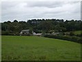
Woolacombe Farm
The farm is in a shallow valley, and is sheltered by high trees on the north
Image: © David Smith
Taken: 13 Aug 2013
0.23 miles