IMAGES TAKEN NEAR TO
Bere Alston, YELVERTON, PL20 7BX
Introduction
This page details the photographs taken nearby to PL20 7BX by members of the Geograph project.
The Geograph project started in 2005 with the aim of publishing, organising and preserving representative images for every square kilometre of Great Britain, Ireland and the Isle of Man.

There are currently over 7.5m images from over14,400 individuals and you can help contribute to the project by visiting https://www.geograph.org.uk
Image Map (Loading...)


Getting Data...Please wait
Leaflet Map data © OpenStreetMap
Images are licensed for reuse under creativecommons.org/licenses/by-sa/2.0
Notes
- Clicking on the map will re-center to the selected point.
- The higher the marker number, the further away the image location is from the centre of the postcode.
Image Listing (7 Images Found)
Images are licensed for reuse under creativecommons.org/licenses/by-sa/2.0
Image
Details
Distance
1
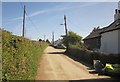
Cotts
A hamlet on a minor lane; this looks in the opposite direction from the same area as the image at Image
Image: © Derek Harper
Taken: 14 Apr 2014
0.02 miles
2
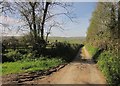
Lane near Cotts
On the left is the start of Bere Ferrers Footpath 71. This is also the location of Gourd’s Shaft, part of the South Tamar Silver-Lead Mine as described at http://www.mindat.org/article.php/81/The+Bere+Peninsula+Silver-Lead+Mines+~+Part+I .
Image: © Derek Harper
Taken: 14 Apr 2014
0.08 miles
3
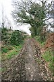
Furzehill Mine
This unsurfaced track follows the course of Furzehill Mine. Furzehill Mine is within the World Heritage Site Area 10: Tamar Valley & Tavistock. The Bere silver mines are amongst the earliest to have been worked as true mines anywhere in Britain; the silver-lead deposits being exploited from the 13th century. The area includes some of the only true silver mines in Britain. Furzehill Mine (also known as Whitsam Down Mine, and possibly also East Tamar Mine) is reputed to date from as early as the beginning of the 16th century and of great historic importance. The track to the south (west of Cotts) is recorded as Bere Ferrers public footpath 71: this track is apparently not recorded at all, but is presumably a minor road.
Image: © Hugh Craddock
Taken: 6 Mar 2011
0.10 miles
4
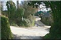
Lower Birch Cross
Crossroads at the intersection of the minor road from Weir Quay to Furzehill Bridge, the minor road north-west to Cotts and Hewton, and the minor unsurfaced road south to Clamoak Quarry and Tuckham Bridge. To the right of the road ahead is Lower Birch Farm. The name of the crossroads is supposition, in the absence of both road names and crossroad names on maps of this area.
Image: © Hugh Craddock
Taken: 6 Mar 2011
0.12 miles
5
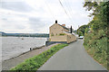
River Tamar at Hole's Hole
Another view of Image looking upstream.
Image: © Kate Jewell
Taken: 19 Aug 2006
0.16 miles
6
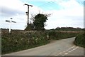
Crossroads on the Bere Alston to Hewton road
To the right is the lane to Cotts, and opposite, just visible, is the unsurfaced road to Whitsam.
Image: © Hugh Craddock
Taken: 6 Mar 2011
0.23 miles
7
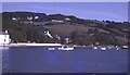
Hole's Hole
View north-east from the river to the quay and the houses at Cotts on the hill. A peaceful scene today, but very industrial in the mid-19th century, when it was the home of the Tamar Smelting Works.
http://www.people.ex.ac.uk/pfclaugh/mhinf/tamar_sw.htm
Image: © Trevor Rickard
Taken: Unknown
0.23 miles