IMAGES TAKEN NEAR TO
Bere Alston, YELVERTON, PL20 7BU
Introduction
This page details the photographs taken nearby to PL20 7BU by members of the Geograph project.
The Geograph project started in 2005 with the aim of publishing, organising and preserving representative images for every square kilometre of Great Britain, Ireland and the Isle of Man.

There are currently over 7.5m images from over14,400 individuals and you can help contribute to the project by visiting https://www.geograph.org.uk
Image Map (Loading...)


Getting Data...Please wait
Leaflet Map data © OpenStreetMap
Images are licensed for reuse under creativecommons.org/licenses/by-sa/2.0
Notes
- Clicking on the map will re-center to the selected point.
- The higher the marker number, the further away the image location is from the centre of the postcode.
Image Listing (16 Images Found)
Images are licensed for reuse under creativecommons.org/licenses/by-sa/2.0
Image
Details
Distance
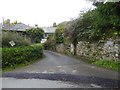
2
West Devon : Clamoak
Houses on the hillside above the River Tamar.
Image: © Lewis Clarke
Taken: 28 Apr 2018
0.02 miles
3
Private Garden at Clamoak
Looking up the hillslope with transmission pylons marching across the horizon.
Image: © Tony Atkin
Taken: 17 Aug 2005
0.06 miles
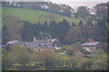
4
Clamoak seen from Tamar
Clamoak appears in 15th century manuscripts referring to the silver mines; one silver lode runs to the north from here.
Image: © David Smith
Taken: 3 Jul 2013
0.07 miles
5
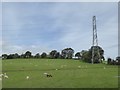
Sheep grazing under the pylon at Clamoak
Image: © David Smith
Taken: 29 Sep 2017
0.11 miles
6
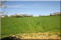
Field by the Tamar Valley Discovery Trail
Looking over the gate and up the field seen in Image
Image: © Derek Harper
Taken: 14 Apr 2014
0.15 miles
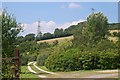
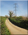
7
Tamar Valley Discovery Trail near Clamoak
The Trail follows a lane inland from the Tamar towards Tuckham Bridge. On the hill to the left, beyond a tree-lined green lane (see Image), is Clamoak Poll Wood.
Image: © Derek Harper
Taken: 14 Apr 2014
0.15 miles
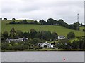
8
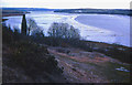
Disused mine, near Weir Quay
View south from the site of South Tamar Consols mine, just south of Weir Quay on the Bere Alston peninsula. Spoil litters the side of the hill. Taken in winter 1979.
Image: © Crispin Purdye
Taken: Unknown
0.18 miles
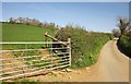
9
Tamar Valley Discovery Trail near Clamoak
Concentrating on the lane aspect of Image
Image: © Derek Harper
Taken: 14 Apr 2014
0.19 miles
10
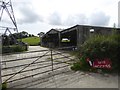
Barn at Clamoak, near the former quarry
Image: © David Smith
Taken: 29 Sep 2017
0.21 miles