IMAGES TAKEN NEAR TO
Pentillie Road, YELVERTON, PL20 7BB
Introduction
This page details the photographs taken nearby to Pentillie Road, PL20 7BB by members of the Geograph project.
The Geograph project started in 2005 with the aim of publishing, organising and preserving representative images for every square kilometre of Great Britain, Ireland and the Isle of Man.

There are currently over 7.5m images from over14,400 individuals and you can help contribute to the project by visiting https://www.geograph.org.uk
Image Map (Loading...)


Getting Data...Please wait
Leaflet Map data © OpenStreetMap
Images are licensed for reuse under creativecommons.org/licenses/by-sa/2.0
Notes
- Clicking on the map will re-center to the selected point.
- The higher the marker number, the further away the image location is from the centre of the postcode.
Image Listing (23 Images Found)
Images are licensed for reuse under creativecommons.org/licenses/by-sa/2.0
Image
Details
Distance
1
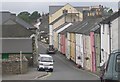
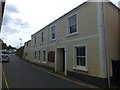
Bere Alston
Bere Alston can be described either as a small town or a large village. This row of terraced cottages near the village centre were probably first erected for miners.
Image: © Tony Atkin
Taken: 19 Aug 2005
0.06 miles
2
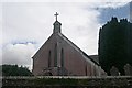
Holy Trinity Church, Bere Alston
This church was built in 1848.
Image: © Tony Atkin
Taken: 19 Aug 2005
0.06 miles
3
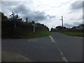
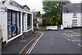
High Cross crossroads, Bere Alston
Here the southbound walker on the Tamar Valley Discovery Trail turns left towards the River Tavy
Image: © David Smith
Taken: 13 Aug 2013
0.07 miles
5
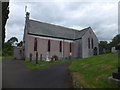
Bere Alston United Church
The building was built in 1811 as the Congregational church. It is now used by the URC and the methodist church
Image: © David Smith
Taken: 13 Aug 2013
0.11 miles
6
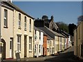
Bere Alston
Terraced houses in Fore Street, shown from the other direction in Image Behind is Holy Trinity Church; see Image
Image: © Derek Harper
Taken: 14 Apr 2014
0.12 miles
7
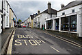
Fore Street, Bere Alston
The village's shopping street, seen from close to its western end at the junction with bedford Street.
Image: © Derek Harper
Taken: 14 Apr 2014
0.17 miles
8
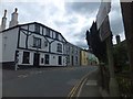
Fore Street, Bere Alston
The Edgcumbe Hotel on the corner, and a Co-operative store further to the south.
Image: © David Smith
Taken: 13 Aug 2013
0.17 miles
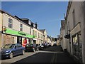
9
Fore Street, Bere Alston
Bere Alston is the principal settlement on the Bere Peninsula, a spit of land between the Rivers Tamar and Tavy. Its heart is Fore Street, seen here from outside the Edgcumbe Hotel.
Image: © Stephen McKay
Taken: 2 May 2022
0.18 miles
10
Fore Street, Bere Alston
This is the northern end of Fore Street with Bedford Street leading off to the right and Station Road to the left. On the immediate left is Bere Peninsula Pharmacy which has lost part of its sign.
Image: © Stephen McKay
Taken: 2 May 2022
0.19 miles