IMAGES TAKEN NEAR TO
Sherrell Park, YELVERTON, PL20 7AZ
Introduction
This page details the photographs taken nearby to Sherrell Park, PL20 7AZ by members of the Geograph project.
The Geograph project started in 2005 with the aim of publishing, organising and preserving representative images for every square kilometre of Great Britain, Ireland and the Isle of Man.

There are currently over 7.5m images from over14,400 individuals and you can help contribute to the project by visiting https://www.geograph.org.uk
Image Map
Images are licensed for reuse under creativecommons.org/licenses/by-sa/2.0
Notes
- Clicking on the map will re-center to the selected point.
- The higher the marker number, the further away the image location is from the centre of the postcode.
Image Listing (20 Images Found)
Images are licensed for reuse under creativecommons.org/licenses/by-sa/2.0
Image
Details
Distance
1
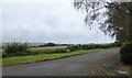
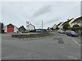
Long Orchard, Bere Alston, and adjacent field
Maize growing on the edge of the village
Image: © David Smith
Taken: 29 Sep 2017
0.08 miles
2
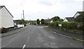
Maynard Road, Bere Alston
Entrance to small housing estate on west of the village
Image: © David Smith
Taken: 29 Sep 2017
0.09 miles
3
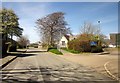
School, Bere Alston
Bere Alston County Primary School is on Station Road.
Image: © Derek Harper
Taken: 14 Apr 2014
0.15 miles
4
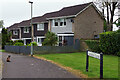
Johnson Close, Bere Alston
A cat glances back at the photographer at the pedestrianised end of Johnson Close where it meets Station Road. The street may have been named after a Percival Johnson, founder of the Tamar Smelting Works (which existed for some years in the 19th century) and a social reformer. The houses date from around 1970.
Image: © Stephen McKay
Taken: 2 May 2022
0.18 miles
7
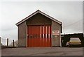
Bere Alston Fire Station
Bere Alston Fire Station, Station Road, Bere Alston, Devon.
Image: © Kevin Hale
Taken: 21 Apr 1991
0.20 miles
8
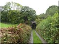
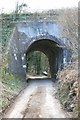
Lockridge Bridge on the west of Bere Alston
The road leads to Lockridge Farm; there is a height warning on the east face, but none on the west face - because if the vehicle has got to the farm, it must satisfy the limit
Image: © David Smith
Taken: 29 Sep 2017
0.20 miles
9
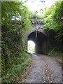
Lockridge Bridge carrying the railway over Lockeridge Lane
Different spellings apply to the bridge name and the road name
Image: © David Smith
Taken: 29 Sep 2017
0.20 miles
10
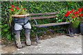
Bench and planter - Bere Alston
The bench is located at the junction of Station Road and Broad Park Road. The trousers and wellies make for a fun touch.
Image: © Stephen McKay
Taken: 2 May 2022
0.21 miles