IMAGES TAKEN NEAR TO
Maynard Park, YELVERTON, PL20 7AR
Introduction
This page details the photographs taken nearby to Maynard Park, PL20 7AR by members of the Geograph project.
The Geograph project started in 2005 with the aim of publishing, organising and preserving representative images for every square kilometre of Great Britain, Ireland and the Isle of Man.

There are currently over 7.5m images from over14,400 individuals and you can help contribute to the project by visiting https://www.geograph.org.uk
Image Map (Loading...)


Getting Data...Please wait
Leaflet Map data © OpenStreetMap
Images are licensed for reuse under creativecommons.org/licenses/by-sa/2.0
Notes
- Clicking on the map will re-center to the selected point.
- The higher the marker number, the further away the image location is from the centre of the postcode.
Image Listing (29 Images Found)
Images are licensed for reuse under creativecommons.org/licenses/by-sa/2.0
Image
Details
Distance
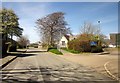
1
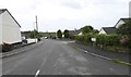
Maynard Road, Bere Alston
Entrance to small housing estate on west of the village
Image: © David Smith
Taken: 29 Sep 2017
0.06 miles
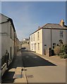
3
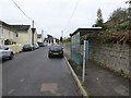
Bus shelter in Station Road, Bere Alston
There is an hourly service between here and Tavistock
Image: © David Smith
Taken: 29 Sep 2017
0.09 miles
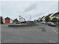
4

Bere Alston Fire Station
Bere Alston Fire Station, Station Road, Bere Alston, Devon.
Image: © Kevin Hale
Taken: 21 Apr 1991
0.09 miles
5

J A N Brown, Bere Alston
This traditional-looking grocery store is located on Station Road, a short distance from the village Co-op which presumably provides some stiff competition. The window includes various advertisements for local services.
Image: © Stephen McKay
Taken: 2 May 2022
0.11 miles
7
School, Bere Alston
Bere Alston County Primary School is on Station Road.
Image: © Derek Harper
Taken: 14 Apr 2014
0.12 miles
8
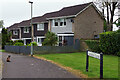
Johnson Close, Bere Alston
A cat glances back at the photographer at the pedestrianised end of Johnson Close where it meets Station Road. The street may have been named after a Percival Johnson, founder of the Tamar Smelting Works (which existed for some years in the 19th century) and a social reformer. The houses date from around 1970.
Image: © Stephen McKay
Taken: 2 May 2022
0.12 miles
9
Station Road, Bere Alston
From close to the war memorial.
Image: © Derek Harper
Taken: 14 Apr 2014
0.12 miles
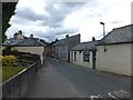
10

Bere Alston War Memorial and Parish Hall
The grade II listed granite war memorial stands in front of the Parish Hall. It commemorates 42 local men who died in the First World War and on the tablet below a further 21 who lost their lives in the Second World War. To the rear (out of shot) the names of ten New Zealand servicemen who were killed in an accident at Bere Ferrers station in 1917 are inscribed. The memorial was unveiled in July 1921.
Image: © Stephen McKay
Taken: 2 May 2022
0.13 miles