IMAGES TAKEN NEAR TO
Two Bridges Road, YELVERTON, PL20 6QS
Introduction
This page details the photographs taken nearby to Two Bridges Road, PL20 6QS by members of the Geograph project.
The Geograph project started in 2005 with the aim of publishing, organising and preserving representative images for every square kilometre of Great Britain, Ireland and the Isle of Man.

There are currently over 7.5m images from over14,400 individuals and you can help contribute to the project by visiting https://www.geograph.org.uk
Image Map
Images are licensed for reuse under creativecommons.org/licenses/by-sa/2.0
Notes
- Clicking on the map will re-center to the selected point.
- The higher the marker number, the further away the image location is from the centre of the postcode.
Image Listing (158 Images Found)
Images are licensed for reuse under creativecommons.org/licenses/by-sa/2.0
Image
Details
Distance
1
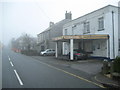
Princetown: Two Bridges Road
This photograph illustrates the demise of the small independent vehicle fuel retailer, even in a place like Princetown which does not have another outlet. At one time the garage on the right would have had pumps with fuel supplied by Keltic, but nowadays residents of Princetown need to go to Tavistock or Yelverton to fill up. Despite the loss of this outlet Keltic still exists as a local independent fuel supplier in East Cornwall and West Devon.
Image: © Nigel Cox
Taken: 6 Oct 2008
0.01 miles
2
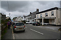
Princetown : Two Bridges Road B3212
Looking along Two Princes Road in Princetown.
Image: © Lewis Clarke
Taken: 6 Aug 2017
0.01 miles
4
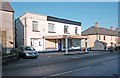
Duchy Square, Princetown
The "Centre for Creativity" is nearing completion: The building in foreground appears to be a residential dwelling, which is directly opposite the Fox Tor Cafe. "Morwenna's House" Image has now been demolished. The building at far left stands on the site of Bolt's Shop and Morwenna House. View taken from the former Methodist chapel.
Image: © MrC
Taken: 2 Jan 2009
0.03 miles
5

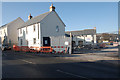
Princetown: Former Methodist Chapel and current Church
The building on the left is the former Wesleyan Methodist Chapel, which certainly existed by 1888 as it shown on the Ordnance Survey map of that year.
Beyond it the white building is The United Church of Princetown - a Methodist/Anglican Ecumenical Partnership created when Image] was closed in 1994. This building was originally a Family Centre and an overnight hostel for Dartmoor prisoners' relations who had travelled a long distance to visit inmates.
The street in the foreground is Two Bridges Road, while the road leading away to the right from the junction is Tor Royal Lane. The Ordnance Survey show a spot height of 416 metres or 1365 feet above sea level at this road junction.
The photograph was taken at dusk on a damp October afternoon with a low cloud base, hence the somewhat murky image.
Image: © Nigel Cox
Taken: 6 Oct 2008
0.04 miles
6
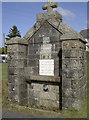
Two Bridges Road water
A public supply of water in Princeton, celebrated by this monument. See Image] for a closer look at some of the details.
Image: © Neil Owen
Taken: 21 Jul 2011
0.04 miles
7
The gift of R.H.Hooker, esq.
Closer look at the sturdy granite drinking fountain in Two Bridges Road. See Image] for an even closer look.
Image: © Neil Owen
Taken: 21 Jul 2011
0.04 miles
8
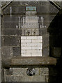
Mixed message?
The small dedication plaque on the drinking fountain seems to be praising the air, not the water. See Image] for a weathered face below the trough.
Image: © Neil Owen
Taken: 21 Jul 2011
0.04 miles
9
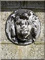
A weathered face
Looks like a lion, although the relevance is not immediately obvious. This is on the drinking fountain in Two Bridges Road, Princeton, and is a gift from a certain R. Hooker. See Image] for a wider view of this particular fountain - one of two along the main roads. See Image] for that example.
Image: © Neil Owen
Taken: 21 Jul 2011
0.04 miles
10
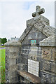
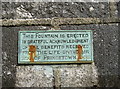
Princetown : Fountain
This fountain is erected in grateful acknowledgement of the benefits received from the life giving air of Princetown.
Image: © Lewis Clarke
Taken: 6 Aug 2017
0.04 miles