IMAGES TAKEN NEAR TO
Plymouth Hill, YELVERTON, PL20 6QH
Introduction
This page details the photographs taken nearby to Plymouth Hill, PL20 6QH by members of the Geograph project.
The Geograph project started in 2005 with the aim of publishing, organising and preserving representative images for every square kilometre of Great Britain, Ireland and the Isle of Man.

There are currently over 7.5m images from over14,400 individuals and you can help contribute to the project by visiting https://www.geograph.org.uk
Image Map
Images are licensed for reuse under creativecommons.org/licenses/by-sa/2.0
Notes
- Clicking on the map will re-center to the selected point.
- The higher the marker number, the further away the image location is from the centre of the postcode.
Image Listing (146 Images Found)
Images are licensed for reuse under creativecommons.org/licenses/by-sa/2.0
Image
Details
Distance
1
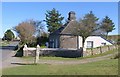
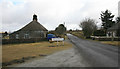
Lodge, Princetown
The southern lodge http://www.britishlistedbuildings.co.uk/en-92791-pair-of-lodges-at-southern-edge-of-prince that corresponds to Image on the other side of the B3212, which can be seen on the left heading into Princetown.
Image: © Derek Harper
Taken: 11 Oct 2010
0.00 miles
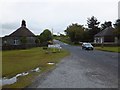
3
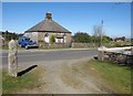
Gatehouses of Princetown
Identical single storey houses, one each side of the road to Yelverton
Image: © David Smith
Taken: 19 Jul 2014
0.01 miles
4
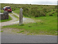
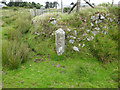
Plymouth Water Works Boundary Stone
One of many Boundary Markers on Dartmoor
Milestone Society ID: DV_PCWW05em
Image: © Mr Red
Taken: 4 Aug 2020
0.01 miles
5
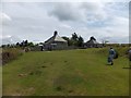
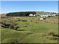
Princetown on the moor
Looking towards the town from the Yelverton Road. Princetown is high on the moor and the wind is blowing rather cold here today. Was the house on the left a Toll house i wonder?
Image: © roger geach
Taken: 9 Mar 2011
0.01 miles
6
Lodge, Princetown
The northern of a pair of identical C19 lodges http://www.britishlistedbuildings.co.uk/en-92791-pair-of-lodges-at-southern-edge-of-prince on either side of Plymouth Hill, the B3212, at the southwest entrance to the town.
Image: © Derek Harper
Taken: 11 Oct 2010
0.02 miles
7
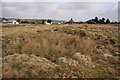
Edge of the moor, Princetown
Hummocky ground just west of Image Walkhampton Bridleway 4 runs on this side of the fence to meet the dismantled railway track shown in Image, and the nearest houses on the right of the conifer wood are called Old and New Station Cottages. On the hill behind is Image
Image: © Derek Harper
Taken: 11 Oct 2010
0.05 miles
8
Plymouth Water Works Boundary Stone
One of many Boundary Markers on Dartmoor
Milestone Society ID: DV_PCWW16em
Image: © Mr Red
Taken: 4 Aug 2020
0.06 miles
9
Soldiers' Pond
This rather disappointing grass filled pond is the pond marked on the OS 1:25000 map. http://www.legendarydartmoor.co.uk/sold_pond.htm
Image: © Guy Wareham
Taken: 10 Mar 2009
0.07 miles
10
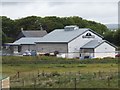
The Dartmoor Brewery
The brewery started in 1994 and one of its brews is known as "Jail Ale"
Image: © David Smith
Taken: 22 Jun 2011
0.08 miles