IMAGES TAKEN NEAR TO
Milton Combe, YELVERTON, PL20 6HR
Introduction
This page details the photographs taken nearby to PL20 6HR by members of the Geograph project.
The Geograph project started in 2005 with the aim of publishing, organising and preserving representative images for every square kilometre of Great Britain, Ireland and the Isle of Man.

There are currently over 7.5m images from over14,400 individuals and you can help contribute to the project by visiting https://www.geograph.org.uk
Image Map (Loading...)


Getting Data...Please wait
Leaflet Map data © OpenStreetMap
Images are licensed for reuse under creativecommons.org/licenses/by-sa/2.0
Notes
- Clicking on the map will re-center to the selected point.
- The higher the marker number, the further away the image location is from the centre of the postcode.
Image Listing (7 Images Found)
Images are licensed for reuse under creativecommons.org/licenses/by-sa/2.0
Image
Details
Distance
1
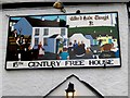
Pub sign - Milton Combe
The "Who'd Have Thought It" pub sign depicts a merry village scene.
Image: © Sarah Smith
Taken: 18 May 2011
0.19 miles
2
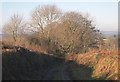
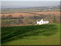
Footpath and Farm Track
The only roadway across this square is a single footpath from Milton Combe in the west to Roborough Down in the east. Whilst being an official footpath it is also a farm track and for much of its length runs between high hedges.
Image: © Tony Atkin
Taken: 11 Dec 2005
0.20 miles
3
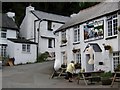
Milton Combe
Milton Combe lies at the bottom of a very steep-sided valley not far from Buckland Abbey. At the centre of the village is a 16C pub called the "Who'd Have Thought It". It would be interesting to find out how it got its name. The cottages around the pub are mostly painted white.
Image: © Sarah Smith
Taken: 18 May 2011
0.20 miles
4
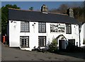
The Who'd Have Thought It
This public house sits at the northern end of the village of Milton Combe, the building almost filling the narrow valley bottom. The pub sign proudly proclaims its 16th century origins. The road to the left of the building climbs very steeply out of the valley heading for Buckland Abbey.
Image: © Tony Atkin
Taken: 11 Dec 2005
0.22 miles
6
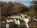
Milton Combe
The northern end of the village, seen from Alley Hill. The pub shown in http://www.geograph.org.uk/search.php?i=38603162 faces the little square from the right. It was probably formerly a farmhouse, according to http://list.english-heritage.org.uk/resultsingle.aspx?uid=1318047&searchtype=mapsearch . Some account of the village is at http://www.bucklandmonachorum.org.uk/Milton.htm .
Image: © Derek Harper
Taken: 11 Dec 2012
0.23 miles
7
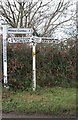
Signposts
Plenty of signposts here so you should not get lost
Image: © roger geach
Taken: 28 Nov 2008
0.24 miles