IMAGES TAKEN NEAR TO
The Leat, YELVERTON, PL20 6FA
Introduction
This page details the photographs taken nearby to The Leat, PL20 6FA by members of the Geograph project.
The Geograph project started in 2005 with the aim of publishing, organising and preserving representative images for every square kilometre of Great Britain, Ireland and the Isle of Man.

There are currently over 7.5m images from over14,400 individuals and you can help contribute to the project by visiting https://www.geograph.org.uk
Image Map (Loading...)


Getting Data...Please wait
Leaflet Map data © OpenStreetMap
Images are licensed for reuse under creativecommons.org/licenses/by-sa/2.0
Notes
- Clicking on the map will re-center to the selected point.
- The higher the marker number, the further away the image location is from the centre of the postcode.
Image Listing (16 Images Found)
Images are licensed for reuse under creativecommons.org/licenses/by-sa/2.0
Image
Details
Distance
1
Walkham Mill, Walkhampton
A water powered former wheelwright's shop that is now in private hands but preserved. When seen it was up for sale. The water wheel is under the low roof to the left. The launder is new but incomplete and the Environment Agency will not allow it to be completed because of flooding concerns. The shop was open to the public for one day on National Mills Open weekend.
Image: © Chris Allen
Taken: 12 May 2018
0.03 miles
2
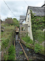
The back of Walkham Mill, Walkhampton
This shows the Black Brook that powered this former wheelwright's shop via a water wheel. In the distance is a new length of wooden launder. This should extend towards the photographer on the lengths of rail above the brook. Unfortunately the Environment Agency has not permitted this due to flooding concerns.
Image: © Chris Allen
Taken: 12 May 2018
0.03 miles
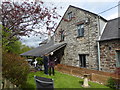
3
Walkhampton near Yelverton
In the foreground is a house called "Old Mill House". Behind is the mid-19th century stone built Walkham Mill that was a water powered wheelwright's shop and worked until the 1980s. It was open for National Mills Weekend.
Image: © Chris Allen
Taken: 12 May 2018
0.03 miles
4
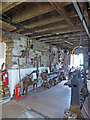
Walkham Mill
A mid-19th century water powered Wheelwright's shop. On the left are a power hacksaw and lathe. The machine right foreground is a tanging and horizontal boring machine. Although the latter was electrically driven, most of the machinery was powered by an overshot water wheel.
Image: © Chris Allen
Taken: 12 May 2018
0.03 miles
5
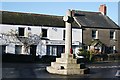
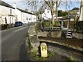
Walkhampton Village War Memorial
This memorial sits in the middle of the road junction at the centre of the village.
Image: © Tony Atkin
Taken: 7 Dec 2008
0.04 miles
6
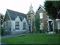
Primary School, Walkhampton, Devon
This traditional style primary school, with its distinctive clock tower is situated on the N side of the small village of Walkhampton. More details of the school can be found in the supplemental image of the school name board.
Image: © Pete Chapman
Taken: 17 Sep 2005
0.04 miles
7
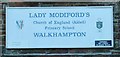
Walkhampton Primary School Name Board
Giving details about the school.
Image: © Pete Chapman
Taken: 17 Sep 2005
0.04 miles
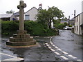
9
Walkhampton village and war memorial
Crossing the stream , the war memorial is in the middle of the road junction.
Image: © roger geach
Taken: 15 Dec 2009
0.05 miles
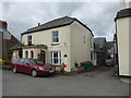
10
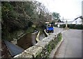
Bridge over Black Brook in Walkhampton
Image: © David Gearing
Taken: 28 Jan 2016
0.05 miles