IMAGES TAKEN NEAR TO
Quarry Park, YELVERTON, PL20 6ER
Introduction
This page details the photographs taken nearby to Quarry Park, PL20 6ER by members of the Geograph project.
The Geograph project started in 2005 with the aim of publishing, organising and preserving representative images for every square kilometre of Great Britain, Ireland and the Isle of Man.

There are currently over 7.5m images from over14,400 individuals and you can help contribute to the project by visiting https://www.geograph.org.uk
Image Map (Loading...)


Getting Data...Please wait
Leaflet Map data © OpenStreetMap
Images are licensed for reuse under creativecommons.org/licenses/by-sa/2.0
Notes
- Clicking on the map will re-center to the selected point.
- The higher the marker number, the further away the image location is from the centre of the postcode.
Image Listing (13 Images Found)
Images are licensed for reuse under creativecommons.org/licenses/by-sa/2.0
Image
Details
Distance
1
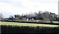
Quarry Park
View to the east. House in middle distance, behind cattle, is Quarry Park. House in far distance among trees is Crapstone House.
Image: © John Cole
Taken: Unknown
0.01 miles
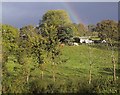
2
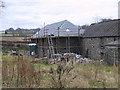
Barns being converted to houses
Stone-built barns, no longer in use for agriculture, are being converted into residential accommodation.
Image: © John Cole
Taken: 24 Dec 2005
0.13 miles
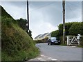
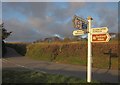
3
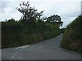
Road junction near Winsbeer
The road to Buckland Monachorum runs north from the junction between the high banks. The road on the left leads into the Tavy valley via the cluster of houses known as Winsbeer.
Image: © David Smith
Taken: 22 Jun 2011
0.16 miles
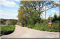
4
The road to Denham Bridge
A minor road running west from Buckland Monachorum leading to the Tavy valley.
Image: © David Smith
Taken: 22 Jun 2011
0.17 miles
5
Bere Alston road via Denham Bridge
Narrow road via Denham bridge to get to Bere Alston but is not suitable for large vehicles at all.
Image: © roger geach
Taken: 17 May 2010
0.18 miles
6
The road to Denham Bridge
It becomes much more narrow and twisty further on but this is a busy route towards Bere Alston. Not for large vehicles though.
Image: © roger geach
Taken: 17 May 2010
0.18 miles
7
Looking towards Buckland Monachorum
The lane from Denham Bridge to Crapstone skirts the southern edge of the village of Buckland Monachorum.
Image: © Tony Atkin
Taken: 15 Mar 2009
0.18 miles
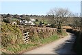
8

View near Higher Paddock play area, Buckland Abbey
The estate walks reach open farmland at the edge of Great North Wood. The prominent house left of centre is at Winsbeer.
Image: © Derek Harper
Taken: 19 May 2018
0.19 miles
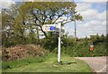
9
Junction, Winsbeer
Image: © Derek Harper
Taken: 5 Mar 2012
0.20 miles