IMAGES TAKEN NEAR TO
Tavistock Road, YELVERTON, PL20 6EF
Introduction
This page details the photographs taken nearby to Tavistock Road, PL20 6EF by members of the Geograph project.
The Geograph project started in 2005 with the aim of publishing, organising and preserving representative images for every square kilometre of Great Britain, Ireland and the Isle of Man.

There are currently over 7.5m images from over14,400 individuals and you can help contribute to the project by visiting https://www.geograph.org.uk
Image Map
Images are licensed for reuse under creativecommons.org/licenses/by-sa/2.0
Notes
- Clicking on the map will re-center to the selected point.
- The higher the marker number, the further away the image location is from the centre of the postcode.
Image Listing (31 Images Found)
Images are licensed for reuse under creativecommons.org/licenses/by-sa/2.0
Image
Details
Distance
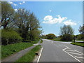
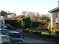
3
Houses and Gardens
The old back road leading westwards from Yelverton is now lined with modern houses with extensive gardens.
Image: © Tony Atkin
Taken: 4 Dec 2005
0.10 miles
4
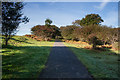
Drakes Trail cycle path
Heading across Roborough Down just after leaving Yelverton.
Image: © jeff collins
Taken: 8 Jan 2014
0.11 miles
6
Suburban Houses and Gardens
Modern housing along Harrowbeer Lane in the village of Yelverton. A jumble of cars complete the scene.
Image: © Tony Atkin
Taken: 4 Dec 2005
0.15 miles
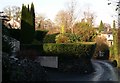
7
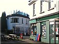
Newsagents, Leg of Mutton - Yelverton
The Leg of Mutton area of Yelverton is an unexpected hidden corner with shops, a pub and restaurant away from the centre of the village. The Tavistock road, the A386, originally passed by here but during WWII the road had to be moved in order to make space for the airfield of RAF Harrowbeer.
Image: © Sarah Smith
Taken: 23 Mar 2011
0.16 miles
8
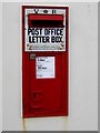
Victorian letter box - Leg of Mutton
Just by the side of the newsagents in a small hidden corner is this old letter box dating from Queen Victoria's reign. It is very much in use and even shows the day of the week.
Image: © Sarah Smith
Taken: 23 Mar 2011
0.16 miles
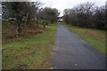
9
Drake's Trail
Soon after leaving Yelverton and before the trail descends to join the old railway trackbed close to where Harrowbeer Station was situated.
Image: © Guy Wareham
Taken: 20 Oct 2016
0.16 miles
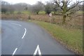
10
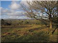
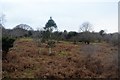
Roborough Down
This open woodland area of the down adjoins the A386 Tavistock Road out of Yelverton.
Image: © Derek Harper
Taken: 5 Mar 2012
0.17 miles