IMAGES TAKEN NEAR TO
Meavy Lane, YELVERTON, PL20 6AE
Introduction
This page details the photographs taken nearby to Meavy Lane, PL20 6AE by members of the Geograph project.
The Geograph project started in 2005 with the aim of publishing, organising and preserving representative images for every square kilometre of Great Britain, Ireland and the Isle of Man.

There are currently over 7.5m images from over14,400 individuals and you can help contribute to the project by visiting https://www.geograph.org.uk
Image Map (Loading...)


Getting Data...Please wait
Leaflet Map data © OpenStreetMap
Images are licensed for reuse under creativecommons.org/licenses/by-sa/2.0
Notes
- Clicking on the map will re-center to the selected point.
- The higher the marker number, the further away the image location is from the centre of the postcode.
Image Listing (82 Images Found)
Images are licensed for reuse under creativecommons.org/licenses/by-sa/2.0
Image
Details
Distance
4
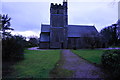
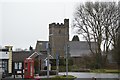
St Paul's Church, Yelverton
Seen here looking South.
Image: © jeff collins
Taken: 15 Jan 2015
0.03 miles
6
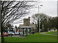
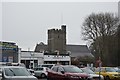
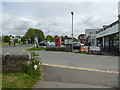
Bus shelter and St Paul's Church Yelverton
View from the B3212 from Princetown on entering Yelverton village centre.
Image: © Sarah Smith
Taken: 21 Dec 2008
0.03 miles
7
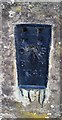
Ordnance Survey Flush Bracket (1741)
This OS Flush Bracket can be found on the NE angle of St Paul's Church. It marks a point 186.270m above mean sea level.
Image: © Adrian Dust
Taken: 26 Apr 2016
0.03 miles