IMAGES TAKEN NEAR TO
Mary Tavy, TAVISTOCK, PL19 9QD
Introduction
This page details the photographs taken nearby to PL19 9QD by members of the Geograph project.
The Geograph project started in 2005 with the aim of publishing, organising and preserving representative images for every square kilometre of Great Britain, Ireland and the Isle of Man.

There are currently over 7.5m images from over14,400 individuals and you can help contribute to the project by visiting https://www.geograph.org.uk
Image Map (Loading...)


Getting Data...Please wait
Leaflet Map data © OpenStreetMap
Images are licensed for reuse under creativecommons.org/licenses/by-sa/2.0
Notes
- Clicking on the map will re-center to the selected point.
- The higher the marker number, the further away the image location is from the centre of the postcode.
Image Listing (6 Images Found)
Images are licensed for reuse under creativecommons.org/licenses/by-sa/2.0
Image
Details
Distance
1
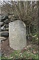
Old Milestone by the A386, Blackdown, Mary Tavy
Carved stone post by the A386, in parish of Mary Tavy (West Devon District), by Royal Standard PH, against wall, on West side of road. Tavistock gable tombstone, erected by the Tavistock turnpike trust in the 19th century.
Inscription reads:-
: (OKEHAMPTON / 12) / MILES : : TAVI / STOCK / 4 / MILES :
Devon & Dartmoor HER.
HER Number: MDV71996 https://www.heritagegateway.org.uk/Gateway/Results_Single.aspx?uid=MDV71996&resourceID=104
Milestone Society National ID: DV_TVOK04
Image: © Alan Rosevear
Taken: 8 Mar 2012
0.12 miles
5
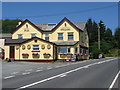
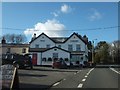
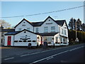
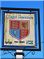
Mary Tavy
A view looking north along the A386 at Mary Tavy, towards the Royal Standard public house, a distinctive sight as you ascend the road through the village.
Image: © Phil Williams
Taken: 16 Jul 2006
0.16 miles