IMAGES TAKEN NEAR TO
Peter Tavy, TAVISTOCK, PL19 9NN
Introduction
This page details the photographs taken nearby to PL19 9NN by members of the Geograph project.
The Geograph project started in 2005 with the aim of publishing, organising and preserving representative images for every square kilometre of Great Britain, Ireland and the Isle of Man.

There are currently over 7.5m images from over14,400 individuals and you can help contribute to the project by visiting https://www.geograph.org.uk
Image Map
Images are licensed for reuse under creativecommons.org/licenses/by-sa/2.0
Notes
- Clicking on the map will re-center to the selected point.
- The higher the marker number, the further away the image location is from the centre of the postcode.
Image Listing (55 Images Found)
Images are licensed for reuse under creativecommons.org/licenses/by-sa/2.0
Image
Details
Distance
2
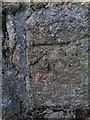
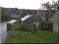
Ordnance Survey Cut Mark
This OS cut mark can be found on the east angle of the barn. It marks a point 165.040m above mean sea level.
Image: © Adrian Dust
Taken: 27 Apr 2016
0.02 miles
8
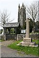
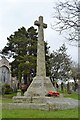
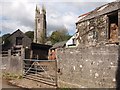
Village Cross, Lych Gate and Church Spire
The church is the Church of St Peter, Peter Tavy. The cross is thought to have been first erected in the 14th Century. It was restored in the year 2000.
Image: © Tony Atkin
Taken: 22 Apr 2006
0.03 miles