IMAGES TAKEN NEAR TO
Horndon, Mary Tavy, TAVISTOCK, PL19 9NF
Introduction
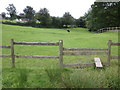
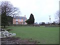
This page details the photographs taken nearby to PL19 9NF by members of the Geograph project.
The Geograph project started in 2005 with the aim of publishing, organising and preserving representative images for every square kilometre of Great Britain, Ireland and the Isle of Man.

There are currently over 7.5m images from over14,400 individuals and you can help contribute to the project by visiting https://www.geograph.org.uk
Image Map
Images are licensed for reuse under creativecommons.org/licenses/by-sa/2.0
Notes
- Clicking on the map will re-center to the selected point.
- The higher the marker number, the further away the image location is from the centre of the postcode.
Image Listing (8 Images Found)
Images are licensed for reuse under creativecommons.org/licenses/by-sa/2.0
Image
Details
Distance
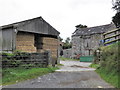
2
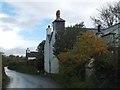
Midlands Farm
The farm and associated buildings extend to the right of the road, facing away from the traffic
Image: © David Smith
Taken: 2 Nov 2012
0.18 miles
7
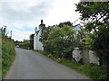
Kingsett
A pink-washed farmhouse at the end of the public road northeast of Mary Tavy.
Image: © Derek Harper
Taken: 28 Jan 2007
0.24 miles