IMAGES TAKEN NEAR TO
Tavy Road, TAVISTOCK, PL19 9HR
Introduction
This page details the photographs taken nearby to Tavy Road, PL19 9HR by members of the Geograph project.
The Geograph project started in 2005 with the aim of publishing, organising and preserving representative images for every square kilometre of Great Britain, Ireland and the Isle of Man.

There are currently over 7.5m images from over14,400 individuals and you can help contribute to the project by visiting https://www.geograph.org.uk
Image Map
Images are licensed for reuse under creativecommons.org/licenses/by-sa/2.0
Notes
- Clicking on the map will re-center to the selected point.
- The higher the marker number, the further away the image location is from the centre of the postcode.
Image Listing (12 Images Found)
Images are licensed for reuse under creativecommons.org/licenses/by-sa/2.0
Image
Details
Distance
1
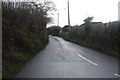
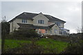
Cox Tor Road, Tavistock
A cul-de-sac forming a crescent from Green Lane, on the Greenlands Estate.
Image: © Derek Harper
Taken: 5 Mar 2012
0.05 miles
4
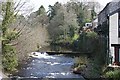
The River Tavy
Looking upstream from Stannary Bridge.
Image: © Tony Atkin
Taken: 22 Apr 2006
0.21 miles
7
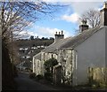
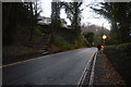
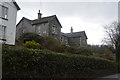
Cottages on Church Hill, Tavistock
On the last steep section of the hill, with the junction with Mount Tavy Road (B3357) at the bottom.
Image: © Derek Harper
Taken: 5 Mar 2012
0.22 miles
8
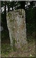
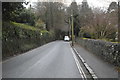
Old Milestone by Green Lane, Whitchurch parish, Tavistock
Carved stone post by the UC road, in parish of WHITCHURCH (WEST DEVON District), Green Lane, West edge of Whitchurch Down; quarter mile North of Tavistock Golf Club, high on grass verge/bank, on East side of road. Tavy granite stone, erected by the Tavistock turnpike trust in the 18th century.
Inscription reads:-
: 1 / T : : 14 / MILES / TO / PLYMo :
Carved benchmark and rivet on top edge.
Devon & Dartmoor HER.
HER Number: MDV3960 https://www.heritagegateway.org.uk/Gateway/Results_Single.aspx?uid=MDV3960&resourceID=104
Milestone Society National ID: DV_PLPTa14.
Image: © T Jenkinson
Taken: 19 Sep 2003
0.22 miles