IMAGES TAKEN NEAR TO
Deer Park Crescent, TAVISTOCK, PL19 9HQ
Introduction
This page details the photographs taken nearby to Deer Park Crescent, PL19 9HQ by members of the Geograph project.
The Geograph project started in 2005 with the aim of publishing, organising and preserving representative images for every square kilometre of Great Britain, Ireland and the Isle of Man.

There are currently over 7.5m images from over14,400 individuals and you can help contribute to the project by visiting https://www.geograph.org.uk
Image Map
Images are licensed for reuse under creativecommons.org/licenses/by-sa/2.0
Notes
- Clicking on the map will re-center to the selected point.
- The higher the marker number, the further away the image location is from the centre of the postcode.
Image Listing (207 Images Found)
Images are licensed for reuse under creativecommons.org/licenses/by-sa/2.0
Image
Details
Distance
1
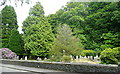
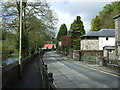
Tavistock cemetery
This seems to be a public cemetery not associated with the church. Its entrance is further to our right.
Image: © Graham Horn
Taken: 29 May 2011
0.12 miles
2
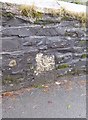
Old Bridge Marker by Dolvin Road, Tavistock Parish
Bridge Marker by the UC road, in parish of Tavistock (West Devon District), Dolvin Road; by St Rumon's graveyard, 50m North of roundabout, low down in stone wall, next to path.
Surveyed
Milestone Society National ID: DV_TVAS00br
Image: © Alan Rosevear
Taken: 22 Mar 2013
0.12 miles
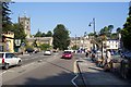
7
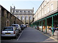
Tavistock, Pannier Market
The Pannier Market is situated behind the Town Hall, which is seen in the background. The building on the left houses the indoor market, while around the outside are the more permanent shops, including the Tourist Information Centre.
Image: © Glen Denny
Taken: 2 Apr 2009
0.15 miles
8
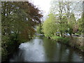
River Tavy, Tavistock
In the distance is Abbey Bridge, built in 1763 and widened in 1860, when the 'new' railway station was opened just up the road and the bridge had a greatly increased traffic flow.
Image: © Richard Rogerson
Taken: 9 Jun 2021
0.15 miles
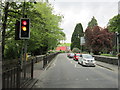
9
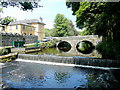
River Tavy at Tavistock Bridge
A fine June afternoon.
Image: © Jonathan Billinger
Taken: 14 Jun 2011
0.15 miles
10
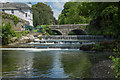
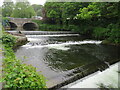
Weir on the River Tavy
The weir is the intake point for the Tavistock Canal which feeds the Morwellham hydro power station.
Image: © Guy Wareham
Taken: 3 Jun 2016
0.15 miles