IMAGES TAKEN NEAR TO
Grenofen, TAVISTOCK, PL19 9ER
Introduction
This page details the photographs taken nearby to PL19 9ER by members of the Geograph project.
The Geograph project started in 2005 with the aim of publishing, organising and preserving representative images for every square kilometre of Great Britain, Ireland and the Isle of Man.

There are currently over 7.5m images from over14,400 individuals and you can help contribute to the project by visiting https://www.geograph.org.uk
Image Map (Loading...)


Getting Data...Please wait
Leaflet Map data © OpenStreetMap
Images are licensed for reuse under creativecommons.org/licenses/by-sa/2.0
Notes
- Clicking on the map will re-center to the selected point.
- The higher the marker number, the further away the image location is from the centre of the postcode.
Image Listing (13 Images Found)
Images are licensed for reuse under creativecommons.org/licenses/by-sa/2.0
Image
Details
Distance
2
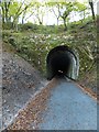
Grenofen tunnel
This tunnel on the former Tavistock to Yelverton railway line has been reopened as part of Drake's Trail for walkers and cyclists. It is part of NCN27. There are lights in part of the tunnel.
Image: © David Smith
Taken: 30 Oct 2012
0.01 miles
3
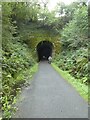
The tunnel at Grenofen on Drake's Trail
Part of the cycle path from Tavistock southwards along the former railway line
Image: © David Smith
Taken: 11 Sep 2021
0.03 miles
4
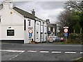
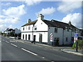
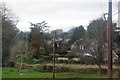
The Halfway House Inn at Grenofen Cross
A large public house sits squarely on the edge of the main road.
Image: © Tony Atkin
Taken: 4 Dec 2005
0.04 miles
7
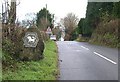
The road through Grenofen
The Dartmoor National Park sign is attached to a large block of granite. It is displayed on this minor road as it crosses the park boundary.
Image: © Tony Atkin
Taken: 4 Dec 2005
0.11 miles
9

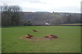
Bridge near Ash Farm for Drakes Trail
Drake's Trail is a footpath and cyclepath (NCN27) between Tavistock and Plymouth, following the former railway line. The bridge is just north of Grenofen Tunnel; the ditch on the left provides drainage for water seeping into the tunnel
Image: © David Smith
Taken: 30 Oct 2012
0.13 miles
10
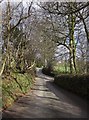
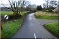
Lane junction west of Grenofen
The lane from Rixhill approaches the junction between banks topped with trees. The right turn is the no through road down to Grenofen Bridge.
Image: © Derek Harper
Taken: 5 Mar 2012
0.14 miles