IMAGES TAKEN NEAR TO
Whitchurch, TAVISTOCK, PL19 9EL
Introduction
This page details the photographs taken nearby to PL19 9EL by members of the Geograph project.
The Geograph project started in 2005 with the aim of publishing, organising and preserving representative images for every square kilometre of Great Britain, Ireland and the Isle of Man.

There are currently over 7.5m images from over14,400 individuals and you can help contribute to the project by visiting https://www.geograph.org.uk
Image Map
Images are licensed for reuse under creativecommons.org/licenses/by-sa/2.0
Notes
- Clicking on the map will re-center to the selected point.
- The higher the marker number, the further away the image location is from the centre of the postcode.
Image Listing (20 Images Found)
Images are licensed for reuse under creativecommons.org/licenses/by-sa/2.0
Image
Details
Distance
1

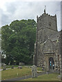
Whitchurch: churchyard
With St Andrew's church beyond
Image: © Martin Bodman
Taken: 17 Jun 2010
0.08 miles
2
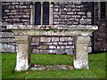
Table tomb St Andrew's Church Whitchurch
An unusual tomb, the coffin being buried below ground and the memorial inscription on the table top.
Image: © Sarah Smith
Taken: 21 Dec 2008
0.09 miles
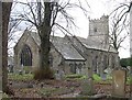
3
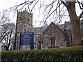
St Andrew's Church Whitchurch
The church is mostly 15th century and is believed to have been built in the white elvan found on Roborough Down hence the name Whitchurch.
Image: © Sarah Smith
Taken: 21 Dec 2008
0.09 miles
4
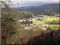
Whitchurch Village
From the road near Higher Woodtown you get a good view of the village with the hills of Dartmoor in the background.
Image: © Tony Atkin
Taken: 4 Dec 2005
0.10 miles
5
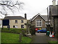
View from the church path - Whitchurch
On the right, facing, is the Children's Centre and on the far right one can see the wall of The Whitchurch Inn.
Image: © Sarah Smith
Taken: 21 Dec 2008
0.10 miles
7
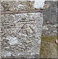
Ordnance Survey Cut Mark
This OS cut mark can be found on the SE face of St Andrew's Church. It marks a point 122.444m above mean sea level.
Image: © Adrian Dust
Taken: 27 Apr 2016
0.10 miles
8
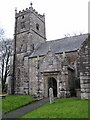
Tower and main entrance St Andrew's Church
The porch has a sundial situated over the doorway.
Image: © Sarah Smith
Taken: 21 Dec 2008
0.10 miles
10
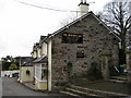
The Whitchurch Inn
First built in 1461 by the monks to provide them with an income. The church gate and steps can be seen on the right of the photograph.
Image: © Sarah Smith
Taken: 21 Dec 2008
0.12 miles