IMAGES TAKEN NEAR TO
Priory Close, TAVISTOCK, PL19 9DH
Introduction
This page details the photographs taken nearby to Priory Close, PL19 9DH by members of the Geograph project.
The Geograph project started in 2005 with the aim of publishing, organising and preserving representative images for every square kilometre of Great Britain, Ireland and the Isle of Man.

There are currently over 7.5m images from over14,400 individuals and you can help contribute to the project by visiting https://www.geograph.org.uk
Image Map
Images are licensed for reuse under creativecommons.org/licenses/by-sa/2.0
Notes
- Clicking on the map will re-center to the selected point.
- The higher the marker number, the further away the image location is from the centre of the postcode.
Image Listing (4 Images Found)
Images are licensed for reuse under creativecommons.org/licenses/by-sa/2.0
Image
Details
Distance
1
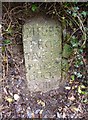
Old Milestone by Whitchurch Road, Tavistock Parish
Carved stone post by the UC road, in parish of TAVISTOCK (WEST DEVON District), Whitchurch Road, 50m South East of Chollacott Lane, opposite No. 132, by road edge in a stone embankment wall, on East side of road. Old Plymouth Dock stone, erected by the Tavistock turnpike trust in the 19th century.
Inscription reads:- : MILES / FROM / TAVK I / PLYMo & / DOCK / XIII :
Milestone Society National ID: DV_PLTVO13
Image: © Alan Rosevear
Taken: 22 Mar 2013
0.09 miles
4
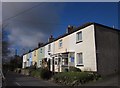
Terrace, Whitchurch Road
Whitchurch Road offers a wide variety of housing types and styles; this colourful terrace is unusual in being so close to the roadway.
Image: © Derek Harper
Taken: 5 Mar 2012
0.24 miles