IMAGES TAKEN NEAR TO
TAVISTOCK, PL19 8NT
Introduction
This page details the photographs taken nearby to PL19 8NT by members of the Geograph project.
The Geograph project started in 2005 with the aim of publishing, organising and preserving representative images for every square kilometre of Great Britain, Ireland and the Isle of Man.

There are currently over 7.5m images from over14,400 individuals and you can help contribute to the project by visiting https://www.geograph.org.uk
Image Map (Loading...)


Getting Data...Please wait
Leaflet Map data © OpenStreetMap
Images are licensed for reuse under creativecommons.org/licenses/by-sa/2.0
Notes
- Clicking on the map will re-center to the selected point.
- The higher the marker number, the further away the image location is from the centre of the postcode.
Image Listing (10 Images Found)
Images are licensed for reuse under creativecommons.org/licenses/by-sa/2.0
Image
Details
Distance
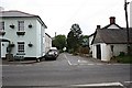
2
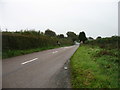
The B3362 nearing Chipshop
Nothing to do with Fish and Chips. And, even more regrettably, the pub is no longer open.
Image: © David Purchase
Taken: 5 Oct 2019
0.01 miles
3
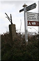
Direction Sign - Signpost by Chipshop Inn, Gulworthy parish
No finial - lost arms; Stone post with metal mount by the UC road, in parish of Gulworthy (West Devon District), Rushford, opposite Chipshop Inn PH, in hedge by new fingerpost.
Surveyed
Milestone Society National ID: DV_SX4375
Image: © Alan Rosevear
Taken: 8 Mar 2012
0.01 miles
4
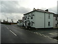
The Chipshop Inn
The name is derived from the local copper-mining heritage.
Image: © Jonathan Billinger
Taken: 4 Feb 2008
0.04 miles
5
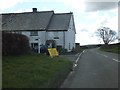
Chipshop
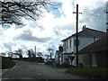
There is a pub, a farm and a few houses, but not a chipshop in sight! The name for this hamlet may have come from old English words for log and workshop, either a log built workshop or a woodworker's shop (a chippies shop!).
Image: © Tony Atkin
Taken: 25 Jun 2006
0.05 miles
6
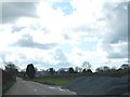
Lay-by and piles of chippings north of Chipshop
Image: © David Smith
Taken: 11 Apr 2012
0.10 miles
7
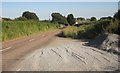
Lay-by, Chipshop
This lay-by and its gravel heaps is shown in Image Ahead, along the B3362, is the hamlet of Chipshop.
Image: © Derek Harper
Taken: 24 Jun 2014
0.11 miles
8
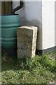
Old Guide Stone by Chapel Cottage, Gulworthy parish
Quays granite guidestone by the UC road, in parish of Gulworthy (West Devon District), by Chapel Cottage (old Methodist chapel), 350m South of Chip Shop Inn, beside turn to Ogbeare, on grass verge at corner of house.
Grade II listed.
List Entry Number: 1305198 https://historicengland.org.uk/listing/the-list/list-entry/1305198
Surveyed
Milestone Society National ID: DV_XGUL01
Image: © Alan Rosevear
Taken: 8 Mar 2012
0.19 miles
9
Junction for Ogbeare south of Chipshop
A handful of houses are clustered at this junction, about three hundred metres south of the village.
Image: © David Smith
Taken: 11 Apr 2012
0.19 miles
10
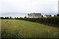
Grass and Houses
The field has been cut for silage, the houses are quite large in an sit on their own in this farming landscape.
Image: © Tony Atkin
Taken: 25 Jun 2006
0.21 miles