IMAGES TAKEN NEAR TO
Bradstone, TAVISTOCK, PL19 0QR
Introduction
This page details the photographs taken nearby to PL19 0QR by members of the Geograph project.
The Geograph project started in 2005 with the aim of publishing, organising and preserving representative images for every square kilometre of Great Britain, Ireland and the Isle of Man.

There are currently over 7.5m images from over14,400 individuals and you can help contribute to the project by visiting https://www.geograph.org.uk
Image Map (Loading...)


Getting Data...Please wait
Leaflet Map data © OpenStreetMap
Images are licensed for reuse under creativecommons.org/licenses/by-sa/2.0
Notes
- Clicking on the map will re-center to the selected point.
- The higher the marker number, the further away the image location is from the centre of the postcode.
Image Listing (7 Images Found)
Images are licensed for reuse under creativecommons.org/licenses/by-sa/2.0
Image
Details
Distance
1
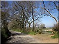
Tamar Valley Discovery Trail near Felldownhead
Just west of the junction with a lane to the B3362. Image was taken from the gateway on the right.
Image: © Derek Harper
Taken: 14 Apr 2015
0.20 miles
2
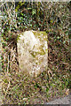
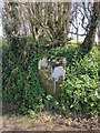
Old Boundary Marker west of Felldown Head, Bradstone parish
Parish Boundary Marker by the UC road, in parish of Bradstone (West Devon District), up hill from Smallacombe, West of Felldown Head, in hedge, opposite field gate at apex of bend.
Inscription reads:-
: Brad / stone : : Dunte / rton :
Grade II listed.
List Entry Number: 1309361 https://historicengland.org.uk/listing/the-list/list-entry/1309361
Surveyed
Milestone Society National ID: DV_DTBS01pb
Image: © Alan Rosevear
Taken: 3 Mar 2013
0.21 miles
3
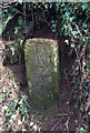
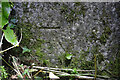
Old Milestone east of Greystone Bridge, Bradstone parish
Carved stone post by the UC road, in parish of Bradstone (West Devon District), old road from Greystone Bridge to Felldown Head; uphill from Smallacombe and Pallastreet Farm, in bank under bushes, on East side of road. Old Tavistock stone, erected by the Tavistock turnpike trust in the 18th century.
Inscription reads:-
(4) Ls n
(8) Tv k
23
Plymo
Devon & Dartmoor HER.
HER Number: MDV63002 https://www.heritagegateway.org.uk/Gateway/Results_Single.aspx?uid=MDV63002&resourceID=104
Milestone Society National ID: DV_TVLA08
Image: © Alan Rosevear
Taken: 3 Mar 2013
0.22 miles
4
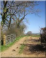
Field entrance east of Felldownhead
From a lane followed by the Tamar Valley Discovery Trail. By the time it reaches the further trees, the field boundary has crossed into Image
Image: © Derek Harper
Taken: 14 Apr 2015
0.23 miles
5
Boundary stone near Felldownhead
The parish boundary stone is described at http://list.historicengland.org.uk/resultsingle.aspx?uid=1104824&searchtype=mapsearch . The parishes in question are Dunterton (right) and Bradstone. During my quick look at it I didn't see any of the lettering.
Image: © Derek Harper
Taken: 14 Apr 2015
0.23 miles
6
Boundary Marker, near Felldownhead
Marking the boundary of Dunterton and Bradstone parishes. At the junction of 2 rural roads. The cut BM representing 176.4 m ASL.
Image: © Sheron Vowden
Taken: 18 Dec 2020
0.23 miles
7
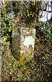
Old Boundary Marker east of Felldown Head, Dunterton Parish
Parish Boundary Marker by the UC road, in parish of Dunterton (West Devon District), at fork, quarter mile South East of Felldown Head, in hedge back at apex of junction.
Inscription reads:-
: Dunte/rton : : Brad/stone :
Grade II listed.
List Entry Number: 1104824 https://historicengland.org.uk/listing/the-list/list-entry/1104824
Surveyed
Milestone Society National ID: DV_DTMA01pb
Image: © Alan Rosevear
Taken: 3 Mar 2013
0.23 miles