IMAGES TAKEN NEAR TO
The Market, TAVISTOCK, PL19 0AL
Introduction
This page details the photographs taken nearby to The Market, PL19 0AL by members of the Geograph project.
The Geograph project started in 2005 with the aim of publishing, organising and preserving representative images for every square kilometre of Great Britain, Ireland and the Isle of Man.

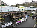
There are currently over 7.5m images from over14,400 individuals and you can help contribute to the project by visiting https://www.geograph.org.uk
Image Map (Loading...)


Getting Data...Please wait
Leaflet Map data © OpenStreetMap
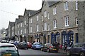
Images are licensed for reuse under creativecommons.org/licenses/by-sa/2.0
Notes
- Clicking on the map will re-center to the selected point.
- The higher the marker number, the further away the image location is from the centre of the postcode.
Image Listing (257 Images Found)
Images are licensed for reuse under creativecommons.org/licenses/by-sa/2.0
Image
Details
Distance
1
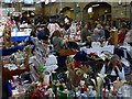
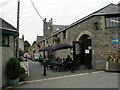
Tavistock Panier Market
A busy Saturday afternoon in the market.
The market building dates from the 1860s.
Image: © Robin Drayton
Taken: 6 Oct 2012
0.00 miles
2
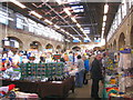
Tavistock Pannier Market
Built as part of the 7th Duke of Bedford's development of the town, the market is still thriving today.
Image: © Rod Allday
Taken: 17 Nov 2010
0.01 miles
3
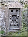
Ordnance Survey Flush Bracket (S5239)
This OS Flush Bracket can be found on the NW face of the Pannier Market. It marks a point 81.780m above mean sea level.
Image: © Adrian Dust
Taken: 8 Apr 2014
0.01 miles
4
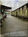
Tavistock Pannier Market
Showing the outside area, which normally has stalls out. But on this day there was heavy showers and it was very windy. To the left under some cover is a good cafe, running the length of the market building.
Image: © jeff collins
Taken: 30 Oct 2023
0.02 miles
5
Pannier Market, Tavistock
The Pannier Market was having major repairs to its fabric with the help of Lottery funding.
Image: © Chris Allen
Taken: 31 Mar 2018
0.02 miles
6
Tavistock Pannier Market
Covered market hall, dating from 1864, though the market has an ancient history. http://www.tavistockpanniermarket.co.uk/index.html
Image: © Mike Faherty
Taken: 28 Jul 2010
0.02 miles
7
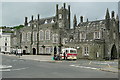
Tavistock Town Hall
Built as part of the development of Tavistock by the 7th Duke of Bedford in the 1860s. The town has a unified estate feel to it, and the Russell's (the family name of the Duke of Bedford and the Marquess of Tavistock) still have influence in the area.
Image: © Graham Horn
Taken: 29 May 2011
0.02 miles
8
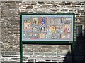
Community Mosaic
Within the Pannier Market is the Community Mosaic. The mosaic depicts prominent sites of archaeological and historical interest in Tavistock and ties in with the 900th anniversary of the granting of the town's market charter celebrated in 2005.
Image: © Michael Dibb
Taken: 27 Sep 2018
0.02 miles
9
Duke St
Grade II listed row. https://www.britishlistedbuildings.co.uk/101309379-9-18-duke-street-tavistock
Image: © N Chadwick
Taken: 2 Dec 2017
0.02 miles
10
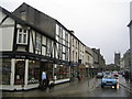
Tavistock: Brook Street & Duke Street
This view was taken looking down Tavistock's main shopping street towards the Church of St Eustachius on a very wet day!
On the left, at 48 Brook Street, is the shop of the thoroughly recommended delicatessen and fine wine merchant, N H Creber, which was established in 1881. The shop stocks a wonderful range of cheeses, jams, marmalade, chutneys, etc., etc. Quaintly, and until very recently, the cost of all purchases in the shop was added up by hand.
Tavistock has a reputation for fine food, and many independent retailers were bitterly opposed to the opening of a McDonald's in the town. However market forces have done their work for them, because in December 2006 McDonald's had to admit that their outlet on the road to Plymouth was "no longer suitable" and would be closing.
Image: © Nigel Cox
Taken: 8 May 2007
0.02 miles