IMAGES TAKEN NEAR TO
North Dimson, GUNNISLAKE, PL18 9PA
Introduction
This page details the photographs taken nearby to PL18 9PA by members of the Geograph project.
The Geograph project started in 2005 with the aim of publishing, organising and preserving representative images for every square kilometre of Great Britain, Ireland and the Isle of Man.

There are currently over 7.5m images from over14,400 individuals and you can help contribute to the project by visiting https://www.geograph.org.uk
Image Map
Images are licensed for reuse under creativecommons.org/licenses/by-sa/2.0
Notes
- Clicking on the map will re-center to the selected point.
- The higher the marker number, the further away the image location is from the centre of the postcode.
Image Listing (10 Images Found)
Images are licensed for reuse under creativecommons.org/licenses/by-sa/2.0
Image
Details
Distance
1
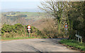
Narrow road with the Tamar valley beyond
Image: © roger geach
Taken: 29 Mar 2012
0.04 miles
2
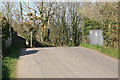
Chilsworthy Railway bridge
The Callington to Gunnislake railway once ran under here. The bridge still remains carrying this minor road over the trackbed.
Image: © roger geach
Taken: 29 Mar 2012
0.07 miles
3
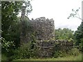
Ruined Engine House
This is one of the derelict mine buildings to be found here on the Skinners Site of the Gunnislake Clitters Mine.
Image: © Tony Atkin
Taken: 30 Jul 2005
0.07 miles
4
Building at North Dimson
Looking in the other direction from the same spot as Image The derelict building occupies part of the site of Gunnislake Clitters Mine http://list.historicengland.org.uk/resultsingle.aspx?uid=1017088&searchtype=mapsearch .
Image: © Derek Harper
Taken: 4 Mar 2015
0.12 miles
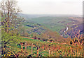
5
Site of Chilsworthy Station
View westward, towards Callington; ex-Plymouth Devonport & South Western Junction (Southern Railway) Bere Alston - Callington branch. The branch had been closed beyond Gunnislake on 7/11/66 and nothing was to be seen here 21 years later!
Image: © Ben Brooksbank
Taken: 2 May 1987
0.13 miles
6
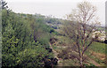
Chilsworthy, 1987: over Tamar Valley towards Launceston
View NW from beside site of former station. (Cf. Image).
Image: © Ben Brooksbank
Taken: 2 May 1987
0.14 miles
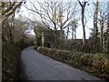
7
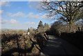
Lane at North Dimson
Just east of the area of Gunnislake Clitters Mine, and approaching the settlement of North Dimson, with a view east to Dartmoor.
Image: © Derek Harper
Taken: 4 Mar 2015
0.18 miles
8
Lane at North Dimson
The view around the corner in Image], with two cottages before the no through road enters Clitters Wood.
Image: © Derek Harper
Taken: 4 Mar 2015
0.22 miles
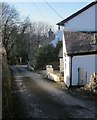
9

Lane at North Dimson
Passing Baker's Cottages on the right, with the start of footpath 606/18/1 a little behind the camera on the right. The lane, a no through road, leads down the side of the Tamar valley through the remnants of Gunnislake Clitters Mine and the hamlet of Bitthams.
Image: © Derek Harper
Taken: 4 Mar 2015
0.24 miles
10
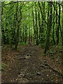
Down through Clitters Woods
This straight track drops very steeply down through the woods to the bottom of the Tamar Valley. The steepness of the incline is not easily apparent in this photograph but it looks downhill.
Image: © Tony Atkin
Taken: 30 Jul 2005
0.25 miles