IMAGES TAKEN NEAR TO
GUNNISLAKE, PL18 9LF
Introduction
This page details the photographs taken nearby to PL18 9LF by members of the Geograph project.
The Geograph project started in 2005 with the aim of publishing, organising and preserving representative images for every square kilometre of Great Britain, Ireland and the Isle of Man.

There are currently over 7.5m images from over14,400 individuals and you can help contribute to the project by visiting https://www.geograph.org.uk
Image Map
Images are licensed for reuse under creativecommons.org/licenses/by-sa/2.0
Notes
- Clicking on the map will re-center to the selected point.
- The higher the marker number, the further away the image location is from the centre of the postcode.
Image Listing (77 Images Found)
Images are licensed for reuse under creativecommons.org/licenses/by-sa/2.0
Image
Details
Distance
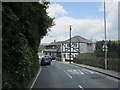
1
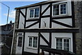
Calstock: Commercial Street, Gunnislake
Most of the shopfronts appear closed, curtained off and presumably converted to private residences
Image: © Martin Bodman
Taken: 16 Sep 2010
0.06 miles
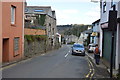
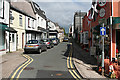
8
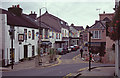
Gunnislake
Showing the junction between Fore Street and Commercial Street, with the A390, Newbridge Hill, heading off to the right.
Image: © Stephen McKay
Taken: Unknown
0.09 miles