IMAGES TAKEN NEAR TO
Sea View Terrace, GUNNISLAKE, PL18 9HX
Introduction
This page details the photographs taken nearby to Sea View Terrace, PL18 9HX by members of the Geograph project.
The Geograph project started in 2005 with the aim of publishing, organising and preserving representative images for every square kilometre of Great Britain, Ireland and the Isle of Man.

There are currently over 7.5m images from over14,400 individuals and you can help contribute to the project by visiting https://www.geograph.org.uk
Image Map
Images are licensed for reuse under creativecommons.org/licenses/by-sa/2.0
Notes
- Clicking on the map will re-center to the selected point.
- The higher the marker number, the further away the image location is from the centre of the postcode.
Image Listing (34 Images Found)
Images are licensed for reuse under creativecommons.org/licenses/by-sa/2.0
Image
Details
Distance
6
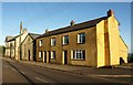
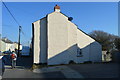
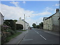
Buildings, St Ann's Chapel
On the right are Sangora Cottages; in the middle is a Methodist Church. These are on the A390 and within the Cornwall and West Devon Mining Landscape World Heritage Site.
Image: © Derek Harper
Taken: 14 May 2014
0.04 miles