IMAGES TAKEN NEAR TO
Delaware, GUNNISLAKE, PL18 9ET
Introduction
This page details the photographs taken nearby to PL18 9ET by members of the Geograph project.
The Geograph project started in 2005 with the aim of publishing, organising and preserving representative images for every square kilometre of Great Britain, Ireland and the Isle of Man.

There are currently over 7.5m images from over14,400 individuals and you can help contribute to the project by visiting https://www.geograph.org.uk
Image Map
Images are licensed for reuse under creativecommons.org/licenses/by-sa/2.0
Notes
- Clicking on the map will re-center to the selected point.
- The higher the marker number, the further away the image location is from the centre of the postcode.
Image Listing (5 Images Found)
Images are licensed for reuse under creativecommons.org/licenses/by-sa/2.0
Image
Details
Distance
1
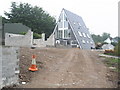
New house, on Station Road, Drakewalls
Image: © Roger Cornfoot
Taken: 2 Jul 2009
0.11 miles
3
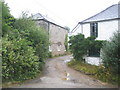
Converted farm buildings, on Station Road
Image: © Roger Cornfoot
Taken: 2 Jul 2009
0.19 miles
4
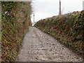
Track near St Ann's Triangulation Pillar
Looking westward.
Image: © Peter Wood
Taken: 28 Mar 2015
0.24 miles
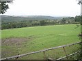
5
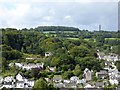
Hills and trees above Gunnislake from Chimney Rock
Image: © David Smith
Taken: 28 Aug 2015
0.25 miles