IMAGES TAKEN NEAR TO
Sand Hill, GUNNISLAKE, PL18 9DR
Introduction
This page details the photographs taken nearby to Sand Hill, PL18 9DR by members of the Geograph project.
The Geograph project started in 2005 with the aim of publishing, organising and preserving representative images for every square kilometre of Great Britain, Ireland and the Isle of Man.

There are currently over 7.5m images from over14,400 individuals and you can help contribute to the project by visiting https://www.geograph.org.uk
Image Map
Images are licensed for reuse under creativecommons.org/licenses/by-sa/2.0
Notes
- Clicking on the map will re-center to the selected point.
- The higher the marker number, the further away the image location is from the centre of the postcode.
Image Listing (75 Images Found)
Images are licensed for reuse under creativecommons.org/licenses/by-sa/2.0
Image
Details
Distance
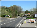
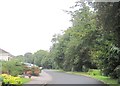
1
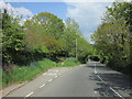
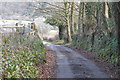
Houses on Sand Hill between Gunnislake and Drakewalls
Image: © David Smith
Taken: 11 Apr 2012
0.02 miles
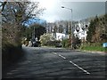
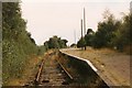
4
Gunnislake 1st railway station (site), Cornwall
Opened in 1908 by the Plymouth, Devonport and South West Junction Railway on its line from Bere Alston to Callington, this station closed in 1994 when it was replaced by a new station some 200m behind the camera position.
View north towards Chilsworthy Halt and Callington. The line had been cut back to terminate here in 1966. The site has been completely redeveloped to be a residential street.
Image: © Nigel Thompson
Taken: 12 Sep 2016
0.10 miles
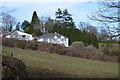
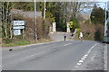
5
Gunnislake old railway station
This is the original railway station at Gunnislake, which at the time this photograph was taken had just been replaced by a shiny new station on the other side of the road, allowing the demolition of a low bridge. Originally, Gunnislake was on the branch to Callington, but became a terminus in 1966 when the line from Gunnislake to Callington was closed. This area is all houses now and completely unrecognisable.
Image: © John Winder
Taken: Unknown
0.10 miles
8
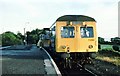
Gunnislake station 1979
As basic as you can get and a 3-car train for 2 passengers, including the photographer.
Image: © Peter Whatley
Taken: Unknown
0.11 miles