IMAGES TAKEN NEAR TO
Alston, CALLINGTON, PL17 8LZ
Introduction
This page details the photographs taken nearby to PL17 8LZ by members of the Geograph project.
The Geograph project started in 2005 with the aim of publishing, organising and preserving representative images for every square kilometre of Great Britain, Ireland and the Isle of Man.

There are currently over 7.5m images from over14,400 individuals and you can help contribute to the project by visiting https://www.geograph.org.uk
Image Map
Images are licensed for reuse under creativecommons.org/licenses/by-sa/2.0
Notes
- Clicking on the map will re-center to the selected point.
- The higher the marker number, the further away the image location is from the centre of the postcode.
Image Listing (3 Images Found)
Images are licensed for reuse under creativecommons.org/licenses/by-sa/2.0
Image
Details
Distance
1
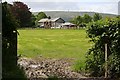
House beyond a grass field
You can always tell when you are looking in the direction of Kit Hill, the monument on the top gives it away.
Image: © Tony Atkin
Taken: 19 May 2007
0.06 miles
2
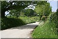
A Country Lane
Hedgerows full of flowers and flanked by trees.
Image: © Tony Atkin
Taken: 19 May 2007
0.08 miles
3
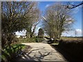
Junction near South Alston
The first of two junctions off this lane between Stoke Climsland and Horsebridge.
Image: © Derek Harper
Taken: 4 Mar 2015
0.11 miles