IMAGES TAKEN NEAR TO
Florence Road, CALLINGTON, PL17 8EB
Introduction
This page details the photographs taken nearby to Florence Road, PL17 8EB by members of the Geograph project.
The Geograph project started in 2005 with the aim of publishing, organising and preserving representative images for every square kilometre of Great Britain, Ireland and the Isle of Man.

There are currently over 7.5m images from over14,400 individuals and you can help contribute to the project by visiting https://www.geograph.org.uk
Image Map
Images are licensed for reuse under creativecommons.org/licenses/by-sa/2.0
Notes
- Clicking on the map will re-center to the selected point.
- The higher the marker number, the further away the image location is from the centre of the postcode.
Image Listing (18 Images Found)
Images are licensed for reuse under creativecommons.org/licenses/by-sa/2.0
Image
Details
Distance
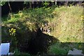
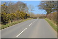
1

Pengelly Lane
This public byway winds along the northeastern edge of Callington.
Image: © Tony Atkin
Taken: 20 Apr 2009
0.04 miles
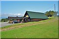
2
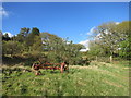
Old Farm Machine
This is opposite someone's house so is probably a bit of a feature rather than just abandoned.
Image: © Des Blenkinsopp
Taken: 29 Apr 2015
0.14 miles
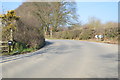
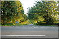
7
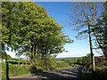
Florence Road
Dropping down from the junction with the track shown in Image
Image: © Derek Harper
Taken: 14 May 2014
0.17 miles
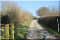
8
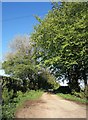
Track to Pengover
Leaving Florence Road at a bend.
Image: © Derek Harper
Taken: 14 May 2014
0.18 miles
9
Florence Hill, Kelly Bray, Callington
The top of Florence Hill, Kelly Bray, Callington, taken from Florence Road on the southwestern slopes of Kit Hill.
Image: © Kevin Hale
Taken: 1 Jun 2006
0.18 miles