IMAGES TAKEN NEAR TO
Redmoor Close, CALLINGTON, PL17 8DW
Introduction
This page details the photographs taken nearby to Redmoor Close, PL17 8DW by members of the Geograph project.
The Geograph project started in 2005 with the aim of publishing, organising and preserving representative images for every square kilometre of Great Britain, Ireland and the Isle of Man.

There are currently over 7.5m images from over14,400 individuals and you can help contribute to the project by visiting https://www.geograph.org.uk
Image Map
Images are licensed for reuse under creativecommons.org/licenses/by-sa/2.0
Notes
- Clicking on the map will re-center to the selected point.
- The higher the marker number, the further away the image location is from the centre of the postcode.
Image Listing (20 Images Found)
Images are licensed for reuse under creativecommons.org/licenses/by-sa/2.0
Image
Details
Distance
1
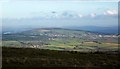
Kelly Bray and Kit Hill from Caradon Hill
With Callington on the right. Taken from the same spot as Image
Image: © Derek Harper
Taken: 13 Dec 2014
0.04 miles
2
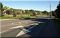
A388 at Kelly Bray
Looking south along the Launceston Road, opposite the bus stop shown in Image The arrows indicate the junction with Florence Road.
Image: © Derek Harper
Taken: 14 May 2014
0.07 miles
3
Bus stop, Kelly Bray
If it's not raining (or snowing), you can sit here and wait for the buses for Callington. If it's raining, you can stand in the shelter.
Image: © Derek Harper
Taken: 14 May 2014
0.08 miles
4
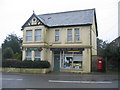
Kelly Bray post office
A view looking west across the A388 towards the post office at Kelly Bray.
Image: © Phil Williams
Taken: 27 Mar 2006
0.09 miles
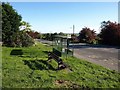
5
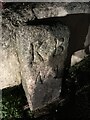
Parish boundary marker, Kelly Bray
Inscription:
KB / N 1
Milestone Society ID: CW_LACL09pb
Image: © Paul Barnett
Taken: 7 Dec 2022
0.09 miles
6
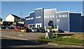
Car sales, Kelly Bray
This bright shiny showroom is between Florence Road (right) and the industrial estate shown in Image
Image: © Derek Harper
Taken: 14 May 2014
0.10 miles
7
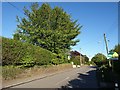
Florence Road, Kelly Bray
The road towards Harrowbarrow, running past houses southeast of the village centre.
Image: © Derek Harper
Taken: 14 May 2014
0.12 miles
8
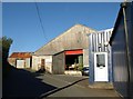
Florence Road Industrial Estate, Kelly Bray
On a lane leading off from the A388. The prominent workshop here houses a plastics components firm.
Image: © Derek Harper
Taken: 14 May 2014
0.13 miles
9
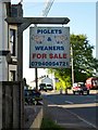
Notice in Kelly Bray
"Piglets and weaners for sale"; a notice beside the A388 in the centre of the village.
Image: © Derek Harper
Taken: 14 May 2014
0.13 miles
10
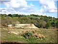
Site of Redmoor mine
A part of the extensive site which was once the Redmoor Mine.
The mine had more or less closed by the 1880s although sporadic reworking continued up to 1943.
But commercial interest in these old mines has not gone away. The Redmoor site has been the subject of recent investigation into whether there's anything worthwhile still here. http://nae.net.au/projects/united-kingdom/redmoor/
Image: © Des Blenkinsopp
Taken: 29 Apr 2015
0.14 miles