IMAGES TAKEN NEAR TO
Norris Green, CALLINGTON, PL17 8DG
Introduction
This page details the photographs taken nearby to PL17 8DG by members of the Geograph project.
The Geograph project started in 2005 with the aim of publishing, organising and preserving representative images for every square kilometre of Great Britain, Ireland and the Isle of Man.

There are currently over 7.5m images from over14,400 individuals and you can help contribute to the project by visiting https://www.geograph.org.uk
Image Map (Loading...)


Getting Data...Please wait
Leaflet Map data © OpenStreetMap
Images are licensed for reuse under creativecommons.org/licenses/by-sa/2.0
Notes
- Clicking on the map will re-center to the selected point.
- The higher the marker number, the further away the image location is from the centre of the postcode.
Image Listing (12 Images Found)
Images are licensed for reuse under creativecommons.org/licenses/by-sa/2.0
Image
Details
Distance
1
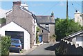
Norris Green
No, not the one in Merseyside. This Cornish hamlet consists of a 19th century terrace of small houses, probably built for miners, and later development.
Image: © Tony Atkin
Taken: 7 Aug 2005
0.00 miles
2
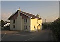
House at Norris Green
Looking to the right from the same spot as Image], which shows that this lane goes to Metherell and Harrowbarrow.
Image: © Derek Harper
Taken: 7 Jun 2013
0.02 miles
3
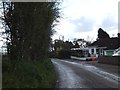
Junction at Norris Green
With a fine old signpost on the left. Image was taken from the same junction and the bungalow appears in both images.
Image: © Derek Harper
Taken: 7 Jun 2013
0.03 miles
4
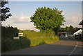
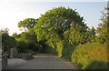
The edge of Norris Green
One side of the road is lined with bungalows, the other is farmland
Image: © David Smith
Taken: 11 Apr 2012
0.03 miles
5
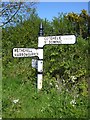
Old Direction Sign - Signpost by Norris green, Calstock Parish
Cone finial - Visick by the UC road, in parish of Calstock (Caradon District), Norris Green, on verge, East side of road.
Surveyed
Milestone Society National ID: CW_SX4169
Image: © Alan Rosevear
Taken: 19 Apr 2014
0.03 miles
6
Lane at Norris Green
Looking behind the camera in Image] along the lane to St Ann's Chapel.
Image: © Derek Harper
Taken: 7 Jun 2013
0.05 miles
7
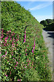
Roadside Flowers at Norris Green
Roadside verges and hedge banks are especially colourful this time of year, with all sorts of wild flowers putting on a show.
Bright pinks and reds from Foxgloves and Campion in this case
Image: © Des Blenkinsopp
Taken: 1 Jun 2017
0.15 miles
8
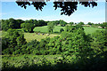
Wooded Valley near Norris Green
Fields and woods towards the top of the Danescombe valley. A short tributary of the Tamar flows down here for around 3kms before joining the river at Calstock.
Image: © Des Blenkinsopp
Taken: 1 Jun 2017
0.21 miles
9
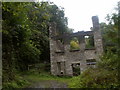
Danescombe Paper Mill
Active in the early 19th Century, this building is now only a shell.
Image: © John Lindsay
Taken: 11 Aug 2008
0.22 miles
10
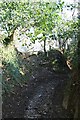
Corner of unsurfaced lane
A sunken unsurfaced lane, which links two minor roads between Danescombe and Norris Green, turns the corner above Danescombe. Straight ahead is an old gateway into the field below, now blocked up.
Image: © Hugh Craddock
Taken: 5 Mar 2011
0.23 miles