IMAGES TAKEN NEAR TO
Lower Metherell, CALLINGTON, PL17 8BJ
Introduction
This page details the photographs taken nearby to PL17 8BJ by members of the Geograph project.
The Geograph project started in 2005 with the aim of publishing, organising and preserving representative images for every square kilometre of Great Britain, Ireland and the Isle of Man.

There are currently over 7.5m images from over14,400 individuals and you can help contribute to the project by visiting https://www.geograph.org.uk
Image Map
Images are licensed for reuse under creativecommons.org/licenses/by-sa/2.0
Notes
- Clicking on the map will re-center to the selected point.
- The higher the marker number, the further away the image location is from the centre of the postcode.
Image Listing (7 Images Found)
Images are licensed for reuse under creativecommons.org/licenses/by-sa/2.0
Image
Details
Distance
2
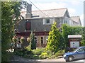
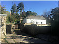
The Cross House Inn, Metherell
This building, as seen in the photograph, does not look much like a public house and indeed it was originally a farmhouse.
Image: © Tony Atkin
Taken: 7 Aug 2005
0.15 miles
3
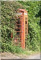
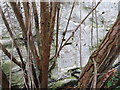
Public Telephone Box, Metherell
Looking like it will soon be completely encased in vegetation, this telephone box seems to have become a victim of the mobile phone. The telephone inside appears to be in working order.
Image: © Tony Atkin
Taken: 7 Aug 2005
0.18 miles
5
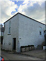
Ordnance Survey Flush Bracket 1919
This can be found on the wall of a building at Metherell.
For more detail see : http://www.bench-marks.org.uk/bm9832
Image: © Peter Wood
Taken: 28 Mar 2015
0.22 miles
7
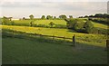
Fields near Clampits
From the lane to Viewtown Nurseries. The farm buildings on the left are on the next lane, from Clampits to Cleave Farm.
Image: © Derek Harper
Taken: 7 Jun 2013
0.25 miles