IMAGES TAKEN NEAR TO
Tillie Street, CALLINGTON, PL17 7PZ
Introduction
This page details the photographs taken nearby to Tillie Street, PL17 7PZ by members of the Geograph project.
The Geograph project started in 2005 with the aim of publishing, organising and preserving representative images for every square kilometre of Great Britain, Ireland and the Isle of Man.

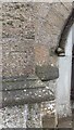
There are currently over 7.5m images from over14,400 individuals and you can help contribute to the project by visiting https://www.geograph.org.uk
Image Map (Loading...)


Getting Data...Please wait
Leaflet Map data © OpenStreetMap
Images are licensed for reuse under creativecommons.org/licenses/by-sa/2.0
Notes
- Clicking on the map will re-center to the selected point.
- The higher the marker number, the further away the image location is from the centre of the postcode.
Image Listing (61 Images Found)
Images are licensed for reuse under creativecommons.org/licenses/by-sa/2.0
Image
Details
Distance
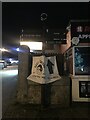
1
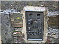
Ordnance Survey Flush Bracket S5217
This can be found on the wall of a private dwelling in Haye Road, Callington.
For more detail see : http://www.bench-marks.org.uk/bm478
Image: © Peter Wood
Taken: 28 Mar 2015
0.02 miles
2
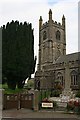
St Mary's Church, Callington
This is the parish church which was built in the early 15th century and restored in the 19th. It is situated at the heart of the town at the western end of Fore Street. In front of the church is the parish war memorial in the traditional Cornish style of a Celtic Cross.
Image: © Tony Atkin
Taken: 14 Oct 2006
0.02 miles
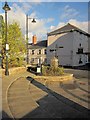
3
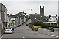
Church Street
Looking up the hill towards St Mary's Church and Fore Street.
Image: © Tony Atkin
Taken: 14 Oct 2006
0.02 miles
4
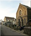
Freemasons Hall, Callington
With its rose window facing George Place, this building dates from 1879. After being the home of the Womens Institute http://www.britishlistedbuildings.co.uk/en-61237-womens-institute-hall-callington , it is now a private house.
Beyond the junction with Valentine Row is the Methodist church, built in 1845.
Image: © Derek Harper
Taken: 1 Nov 2011
0.03 miles
5
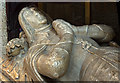
St Mary's church, Callington - tomb of Sir Robert Willoughby de Broke (detail)
Image: © Mike Searle
Taken: 28 Jun 2013
0.04 miles
6
Callington Old Fire Station
Callington Old Fire Station, Haye Road, Callington, Cornwall. Now replaced by a new fire station on South Hill Road. Image
Image: © Kevin Hale
Taken: 26 Sep 2004
0.04 miles
7
Signpost in Callington town centre
Callington Community College
Town Hall
Pannier Market
Image: © Paul Barnett
Taken: 7 Dec 2022
0.04 miles
8
Signpost Callington Pannier Market
Oxfam
The Barber Shop
Image: © Paul Barnett
Taken: 7 Dec 2022
0.04 miles
9
Steps by the church, Callington
An attractive piece of public realm by the junction of Fore Street with Church Street, the street in the background. The Bull's Head on the corner is described at http://www.britishlistedbuildings.co.uk/en-61229-bulls-head-public-house-callington- .
Image: © Derek Harper
Taken: 5 Nov 2014
0.04 miles